IMAGES TAKEN NEAR TO
West Street, TETBURY, GL8 8DR
Introduction
This page details the photographs taken nearby to West Street, GL8 8DR by members of the Geograph project.
The Geograph project started in 2005 with the aim of publishing, organising and preserving representative images for every square kilometre of Great Britain, Ireland and the Isle of Man.

There are currently over 7.5m images from over14,400 individuals and you can help contribute to the project by visiting https://www.geograph.org.uk
Image Map
Images are licensed for reuse under creativecommons.org/licenses/by-sa/2.0
Notes
- Clicking on the map will re-center to the selected point.
- The higher the marker number, the further away the image location is from the centre of the postcode.
Image Listing (895 Images Found)
Images are licensed for reuse under creativecommons.org/licenses/by-sa/2.0
Image
Details
Distance
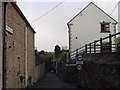
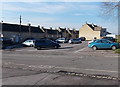
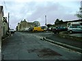
1
West Street Tetbury
The houses in this part of West Street face a car park.
Image: © Jaggery
Taken: 13 Jan 2013
0.00 miles
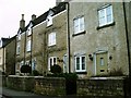
2
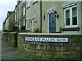
Prince of Wales Row in West Street Tetbury
Image: © Paul Best
Taken: 1 Feb 2014
0.00 miles
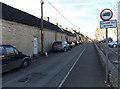
4
A Tetbury car park
Viewed from Old Brewery Lane looking towards houses in West Street.
Image: © Jaggery
Taken: 13 Jan 2013
0.01 miles
6
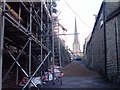
Cottons Lane Tetbury
West Street land slippage repair work closes Cottons Lane Tetbury.
Image: © Paul Best
Taken: 28 Dec 2013
0.03 miles
8

Fields and houses in Tetbury
A view to the NW from Bath Bridge. http://www.geograph.org.uk/photo/4189855
The houses are in Cotton's Lane and West Street.
Image: © Jaggery
Taken: 13 Jan 2013
0.04 miles
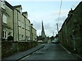
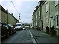
9
West Street looking towards Cutwell Tetbury
Image: © Paul Best
Taken: 1 Feb 2014
0.04 miles