IMAGES TAKEN NEAR TO
North Cerney, CIRENCESTER, GL7 7FE
Introduction
This page details the photographs taken nearby to GL7 7FE by members of the Geograph project.
The Geograph project started in 2005 with the aim of publishing, organising and preserving representative images for every square kilometre of Great Britain, Ireland and the Isle of Man.

There are currently over 7.5m images from over14,400 individuals and you can help contribute to the project by visiting https://www.geograph.org.uk
Image Map
Images are licensed for reuse under creativecommons.org/licenses/by-sa/2.0
Notes
- Clicking on the map will re-center to the selected point.
- The higher the marker number, the further away the image location is from the centre of the postcode.
Image Listing (6 Images Found)
Images are licensed for reuse under creativecommons.org/licenses/by-sa/2.0
Image
Details
Distance
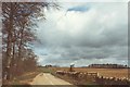
2
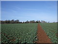
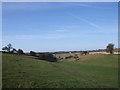
Bridlepath across North Cerney Downs
Bridlepath across arable field on North Cerney Downs.
Image: © Vieve Forward
Taken: 26 Feb 2012
0.03 miles
3
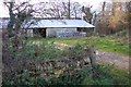
Barn at The Red Sheds
Not a red shed in sight!
Image: © Jonathan Billinger
Taken: 27 Nov 2006
0.05 miles
4
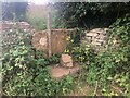
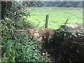
Stone Stile, North Cerney
On Gloucestershire footpath BNC17 looking West, the view East is Image
Image: © Jayne Tovey
Taken: 25 Apr 2023
0.07 miles
5
Stone Stile, North Cerney
On Gloucestershire footpath BNC17 looking East, the view West is Image
Image: © Jayne Tovey
Taken: 25 Apr 2023
0.07 miles
6
View towards Sladbottom Copse
View from the edge of the North Cerney Downs towards Sladbottom Copse.
Image: © Vieve Forward
Taken: 26 Feb 2012
0.12 miles