IMAGES TAKEN NEAR TO
Cheltenham Road, CIRENCESTER, GL7 7ET
Introduction
This page details the photographs taken nearby to Cheltenham Road, GL7 7ET by members of the Geograph project.
The Geograph project started in 2005 with the aim of publishing, organising and preserving representative images for every square kilometre of Great Britain, Ireland and the Isle of Man.

There are currently over 7.5m images from over14,400 individuals and you can help contribute to the project by visiting https://www.geograph.org.uk
Image Map
Images are licensed for reuse under creativecommons.org/licenses/by-sa/2.0
Notes
- Clicking on the map will re-center to the selected point.
- The higher the marker number, the further away the image location is from the centre of the postcode.
Image Listing (12 Images Found)
Images are licensed for reuse under creativecommons.org/licenses/by-sa/2.0
Image
Details
Distance
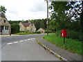
1
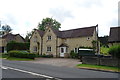
Houses on the A435, Marsden
The one to the right has been significantly extended.
See Image] for context.
Image: © JThomas
Taken: 11 Jul 2019
0.00 miles
2
The A435 passing Memory Lodge
Looking south-east along the main road near Marsden.
Image: © Ruth Riddle
Taken: 21 Jul 2012
0.01 miles
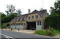
3
This building is called Memory Lodge.
Situated by the A435 between Colesbourne and Rendcomb
Image: © Jonathan Billinger
Taken: 27 Nov 2006
0.02 miles
4
Memory Lodge, Marsden
On the A435.
See Image] for context.
Image: © JThomas
Taken: 11 Jul 2019
0.02 miles
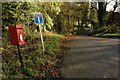
5
Cheltenham Road, Marsden
The A435.
Showing position of Postbox No. GL7 56.
See Image] for postbox.
Image: © JThomas
Taken: 11 Jul 2019
0.02 miles
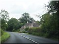
6
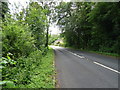
A435 approaching Memory Lodge
Towards Cirencester.
Image: © JThomas
Taken: 11 Jul 2019
0.02 miles
7
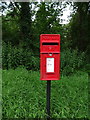
Elizabeth II postbox on Cheltenham Road, Marsden
Postbox No. GL7 56.
See Image] for context.
Image: © JThomas
Taken: 11 Jul 2019
0.03 miles
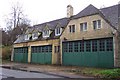
8

Memory Lodge
Also shown in Image and Image Next to the lodge are a pair of semi-detached cottages. The A435 is the main road, heading for Cheltenham. The wood in the background is Lincombe Inclosure.
Image: © Derek Harper
Taken: 21 Mar 2015
0.05 miles
9
Road to Marsden
The road to Marsden in the Churn Valley at its junction with the A435.
Image: © Philip Halling
Taken: 7 Nov 2009
0.07 miles
10
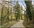
Entrance drive to Marsden Manor
Seen from the A435, a few metres from where Image was taken. The lane drops to cross the Churn (bridge parapet just visible) to reach the Arts and Crafts-designed house http://list.historicengland.org.uk/resultsingle.aspx?uid=1090159&searchtype=mapsearch , discernible through the trees.
Image: © Derek Harper
Taken: 21 Mar 2015
0.07 miles