IMAGES TAKEN NEAR TO
The Park, CIRENCESTER, GL7 6LX
Introduction
This page details the photographs taken nearby to The Park, GL7 6LX by members of the Geograph project.
The Geograph project started in 2005 with the aim of publishing, organising and preserving representative images for every square kilometre of Great Britain, Ireland and the Isle of Man.

There are currently over 7.5m images from over14,400 individuals and you can help contribute to the project by visiting https://www.geograph.org.uk
Image Map
Images are licensed for reuse under creativecommons.org/licenses/by-sa/2.0
Notes
- Clicking on the map will re-center to the selected point.
- The higher the marker number, the further away the image location is from the centre of the postcode.
Image Listing (24 Images Found)
Images are licensed for reuse under creativecommons.org/licenses/by-sa/2.0
Image
Details
Distance
2
![A walk through Cirencester Park and Stratton [17]](https://s0.geograph.org.uk/geophotos/06/84/49/6844920_cd26dd8c_120x120.jpg)
A walk through Cirencester Park and Stratton [17]
Lots of wild garlic alongside the path.
Cirencester Park is a private estate of some 2,500 acres consisting of extensive woodland, with park and pleasure grounds. The park was developed from circa 1714 by the first Earl Bathurst. The park is on the Register of Historic Parks and Gardens, grade I, and there are details at: https://historicengland.org.uk/listing/the-list/list-entry/1000432
Image: © Michael Dibb
Taken: 12 May 2021
0.08 miles
4
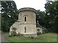
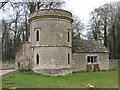
Round Tower, Cirencester Park
Round Tower in Cirencester Park is a folly which is lived in.
Image: © Philip Halling
Taken: 27 Dec 2011
0.12 miles
5
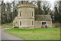
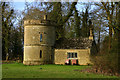
![A walk through Cirencester Park and Stratton [16]](https://s3.geograph.org.uk/geophotos/06/84/49/6844919_0e5079a8_120x120.jpg)
A walk through Cirencester Park and Stratton [16]
The Round Tower is a landscape building, a circular tower in neo-medieval style with a later wing. Constructed in the early/mid 18th century with an early 19th century addition. Built in coursed squared limestone rubble with ashlar dressings and a stone slate roof. Listed, grade II, with details at: https://historicengland.org.uk/listing/the-list/list-entry/1204830
Cirencester Park is a private estate of some 2,500 acres consisting of extensive woodland, with park and pleasure grounds. The park was developed from circa 1714 by the first Earl Bathurst. The park is on the Register of Historic Parks and Gardens, grade I, and there are details at: https://historicengland.org.uk/listing/the-list/list-entry/1000432
Image: © Michael Dibb
Taken: 12 May 2021
0.12 miles
7
![A walk through Cirencester Park and Stratton [19]](https://s3.geograph.org.uk/geophotos/06/84/49/6844923_d02e47c1_120x120.jpg)
A walk through Cirencester Park and Stratton [19]
By the corner of the reservoir, a track leads out of the woodland into open fields.
Cirencester Park is a private estate of some 2,500 acres consisting of extensive woodland, with park and pleasure grounds. The park was developed from circa 1714 by the first Earl Bathurst. The park is on the Register of Historic Parks and Gardens, grade I, and there are details at: https://historicengland.org.uk/listing/the-list/list-entry/1000432
Image: © Michael Dibb
Taken: 12 May 2021
0.13 miles
8
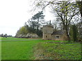
The Round House
Folly in Cirencester Park
Image: © Paul Brooker
Taken: 10 Mar 2010
0.14 miles
9
The Round House - Cirencester Park
Another folly, but this one is lived in.
Image: © Mike Baldwin
Taken: 22 Feb 2007
0.15 miles
10
![A walk through Cirencester Park and Stratton [18]](https://s2.geograph.org.uk/geophotos/06/84/49/6844922_3fda7306_120x120.jpg)
A walk through Cirencester Park and Stratton [18]
The surfaced roadway runs just inside the edge of the woodland.
Cirencester Park is a private estate of some 2,500 acres consisting of extensive woodland, with park and pleasure grounds. The park was developed from circa 1714 by the first Earl Bathurst. The park is on the Register of Historic Parks and Gardens, grade I, and there are details at: https://historicengland.org.uk/listing/the-list/list-entry/1000432
Image: © Michael Dibb
Taken: 12 May 2021
0.15 miles