IMAGES TAKEN NEAR TO
Nursery View, CIRENCESTER, GL7 6HN
Introduction
This page details the photographs taken nearby to Nursery View, GL7 6HN by members of the Geograph project.
The Geograph project started in 2005 with the aim of publishing, organising and preserving representative images for every square kilometre of Great Britain, Ireland and the Isle of Man.

There are currently over 7.5m images from over14,400 individuals and you can help contribute to the project by visiting https://www.geograph.org.uk
Image Map
Images are licensed for reuse under creativecommons.org/licenses/by-sa/2.0
Notes
- Clicking on the map will re-center to the selected point.
- The higher the marker number, the further away the image location is from the centre of the postcode.
Image Listing (41 Images Found)
Images are licensed for reuse under creativecommons.org/licenses/by-sa/2.0
Image
Details
Distance
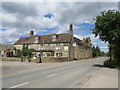
1
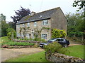
Roadside house
This attractive house is alongside the minor road.
Image: © Michael Dibb
Taken: 12 Aug 2012
0.10 miles
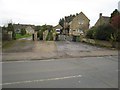
2
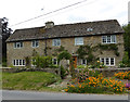
Cottage, Siddington
Cotswold stone cottage.
Image: © Vieve Forward
Taken: 21 Jul 2016
0.10 miles
3
![Once were trains [2]](https://s0.geograph.org.uk/geophotos/03/11/39/3113960_87abb850_120x120.jpg)
Once were trains [2]
The bridge abutments are all that remains of the dismantled Midland and South Western Junction Railway. It is obvious that the bridge, which carried the line over Ashton Road, was originally built for a single track and later widened. The M&SWJR was independent and a north-south link between the Midland and London and South Western Railways. The route allowed Midland trains (and others) from Liverpool, Bradford and Manchester to reach the port at Southampton. The line closed in 1961.
Image: © Michael Dibb
Taken: 12 Aug 2012
0.11 miles
4
![Once were trains [1]](https://s3.geograph.org.uk/geophotos/03/11/39/3113947_0f622de8_120x120.jpg)
Once were trains [1]
The bridge abutments are all that remains of the dismantled Midland and South Western Junction Railway. The M&SWJR was independent and a north-south link between the Midland and London and South Western Railways. The route allowed Midland trains (and others) from Liverpool, Bradford and Manchester to reach the port at Southampton. The line closed in 1961.
Image: © Michael Dibb
Taken: 12 Aug 2012
0.12 miles
5
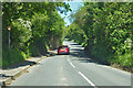
Dismantled railway bridge, Ashton Road, Siddington
The old Midland and South Western Junction Railway route, that closed here to all traffic in 1964.
Image: © Robin Webster
Taken: 30 May 2021
0.12 miles
6
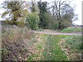
Lane to Plummer's Farm
The access road to Plummer's Farm crosses the bed of the Thames & Severn Canal on a causeway at this point. Clearly a new bridge will be required in order to restore navigation.
Image: © David Stowell
Taken: 5 Nov 2008
0.15 miles
7
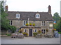
The Greyhound
A fine establishment which serves excellent Sunday lunches. The building dates from early/mid 19th century, is listed grade II and further details are here https://historicengland.org.uk/listing/the-list/list-entry/1090071
Image: © Michael Dibb
Taken: 12 Aug 2012
0.16 miles
8

The Greyhound pub, Siddington
Village pub.
Image: © Vieve Forward
Taken: 21 Jul 2016
0.16 miles
9
The Greyhound, Siddington
The Greyhound pub in the village of Siddington, near Cirencester in Gloucestershire.
At the time this image was taken, the pub was closed as a result of coronavirus restrictions which had been imposed in March 2020. It was preparing to reopen later in July 2020.
Image: © Malc McDonald
Taken: 11 Jul 2020
0.16 miles
10
Siddington - line of lower lock
The Thames & Severn Canal towpath is now a narrow footpath between these two houses. The house to the right stands on the site of Siddington Lower Lock, at the bottom of the Siddington flight. The house was built in the 1970s - and is the only one obstructing the whole 37 miles of the Cotswold Canals. Today nothing can be seen of the lock or of the bridge which carried the road across the canal below it.
Image: © David Stowell
Taken: 5 Nov 2008
0.16 miles