IMAGES TAKEN NEAR TO
Lime Crescent, GL7 6GF
Introduction
This page details the photographs taken nearby to Lime Crescent, GL7 6GF by members of the Geograph project.
The Geograph project started in 2005 with the aim of publishing, organising and preserving representative images for every square kilometre of Great Britain, Ireland and the Isle of Man.

There are currently over 7.5m images from over14,400 individuals and you can help contribute to the project by visiting https://www.geograph.org.uk
Image Map
Images are licensed for reuse under creativecommons.org/licenses/by-sa/2.0
Notes
- Clicking on the map will re-center to the selected point.
- The higher the marker number, the further away the image location is from the centre of the postcode.
Image Listing (12 Images Found)
Images are licensed for reuse under creativecommons.org/licenses/by-sa/2.0
Image
Details
Distance
2
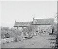
Preston Mill
Preston Mill was recently on the market and it included the five bedroom 18th Century millers house and the attached former mill. There are many outbuildings including including a 50ft long barn.
As well as everything else it has a tennis court, some paddocks (about 6.3 acres) and rights to single bank fishing on the river Churn.
It was on the market in 2010 at £1.25 million
Image: © Nigel Mykura
Taken: 17 Jun 2012
0.13 miles
3
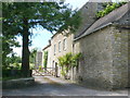
Cottages at Siddington
This pair of what appear to be substantial estate cottages are close to Siddington House on the road from Siddington to Preston
Image: © Nigel Mykura
Taken: 17 Jun 2012
0.14 miles
5
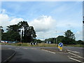
Roundabout on Ermine Way approaching Cirencester
Image: © Roy Hughes
Taken: 20 Jun 2020
0.16 miles
6
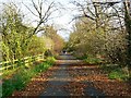
Cricklade Road, Cirencester
Not so many years ago this leafy lane was the main road to Gloucester from the south. It is an old Roman road, Ermin Street. It has been by-passed and gated at the viewpoint but access is allowed for recreational uses such as dog-walking.
Image: © Brian Robert Marshall
Taken: 10 Nov 2007
0.17 miles
8
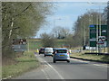
Dual carriageway section of the A419 north of Siddington
Image: © Sarah Charlesworth
Taken: 4 Mar 2010
0.20 miles
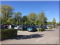
9
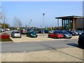
Car park, Dobbies Garden Centre, Siddington
Dobbies is a chain of garden centres whose origins date to the 19th century when a Scottish policeman-turned-nurseryman named James Dobbie started the business. The chain joined the Tesco group of companies in 2008 but remains operationally independent with its headquarters in Edinburgh. This image is also of note in that it shows a very well-maintained 1975 MGB roadster just to the right of centre. British sports cars such as the MGB were once aspired to by the likes of this contributor. They were built from 1962 to 1980 at the MG factory in Abingdon, now sadly long-gone. Because most of the production run was exported to the USA the original design had to be increasingly modified to meet the statutory requirements of that country as they became ever more stringent as regards exhaust emissions and safety. As a result later models are decidedly lacklustre in performance when compared to the early examples. The one shown here would be left for dead by the diesel-powered Toyota parked next to it. Thankfully outright performance isn't everything and, for dawdling along a country lane on a warm summer's evening with your blonde du jour in the passenger seat with the top down, the B would be hard to beat.
Image: © Brian Robert Marshall
Taken: 17 Mar 2011
0.21 miles
10

Entrance to Dobbies Garden Centre and Restaurant
On the outskirts of Cirencester.
Image: © Russel Wills
Taken: 28 Jul 2015
0.21 miles