IMAGES TAKEN NEAR TO
Lower Mill Lane, CIRENCESTER, GL7 6FU
Introduction
This page details the photographs taken nearby to Lower Mill Lane, GL7 6FU by members of the Geograph project.
The Geograph project started in 2005 with the aim of publishing, organising and preserving representative images for every square kilometre of Great Britain, Ireland and the Isle of Man.

There are currently over 7.5m images from over14,400 individuals and you can help contribute to the project by visiting https://www.geograph.org.uk
Image Map
Images are licensed for reuse under creativecommons.org/licenses/by-sa/2.0
Notes
- Clicking on the map will re-center to the selected point.
- The higher the marker number, the further away the image location is from the centre of the postcode.
Image Listing (18 Images Found)
Images are licensed for reuse under creativecommons.org/licenses/by-sa/2.0
Image
Details
Distance
1
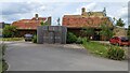
Holiday house at Cotswold Water Park
A nice touch with the 'green' roofs
Image: © TCExplorer
Taken: 28 May 2023
0.02 miles
3
The youthful River Thames seen from a bridge to the Lower Mill Estate, Somerford Keynes
Image: © Ruth Sharville
Taken: 20 Jan 2022
0.13 miles
4
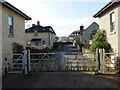
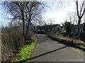
Gated road to Lower Mill Estate, Somerford Keynes
The photo was taken from a bridge over the youthful River Thames Image
Image: © Ruth Sharville
Taken: 20 Jan 2022
0.13 miles
5
The Thames Path - approaching where the tarmac ends, Somerford Keynes
Image: © Ruth Sharville
Taken: 20 Jan 2022
0.14 miles
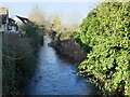
6
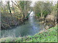
Bend in the youthful River Thames beside the Thames Path, Somerford Keynes
I hesitate to describe this as a "meander" - which would be the usual term for a bend in the river, as the course has been so heavily "managed" in this area.
Image: © Ruth Sharville
Taken: 20 Jan 2022
0.16 miles
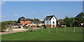
7
Holiday homes from the Thames Path
Sorry to be political but this country has several thousands of people without homes, yet these properties lie empty for most of the year. Enough said.
Image: © Row17
Taken: 6 Jul 2011
0.17 miles
8

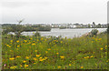
New access road to the Lower Mill Estate, Somerford Keynes
The estate lies between the youthful River Thames and the gravel pit lakes prevalent in this area.
Image: © Ruth Sharville
Taken: 20 Jan 2022
0.17 miles
9

Access path from the road to Mill Lane, Somerford Keynes
Opposite this path, across the road, is a road that forms part of the Thames Path.
Image: © Ruth Sharville
Taken: 20 Jan 2022
0.21 miles
10
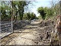
Bridleway near fenced-off lake
The fierce fencing of the private fishing lake to the south has preserved the bridleway but not in the prettiest state.
Image: © Vieve Forward
Taken: 4 May 2016
0.21 miles