IMAGES TAKEN NEAR TO
Top Farm, CIRENCESTER, GL7 6FA
Introduction
This page details the photographs taken nearby to Top Farm, GL7 6FA by members of the Geograph project.
The Geograph project started in 2005 with the aim of publishing, organising and preserving representative images for every square kilometre of Great Britain, Ireland and the Isle of Man.

There are currently over 7.5m images from over14,400 individuals and you can help contribute to the project by visiting https://www.geograph.org.uk
Image Map
Images are licensed for reuse under creativecommons.org/licenses/by-sa/2.0
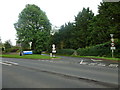
Notes
- Clicking on the map will re-center to the selected point.
- The higher the marker number, the further away the image location is from the centre of the postcode.
Image Listing (148 Images Found)
Images are licensed for reuse under creativecommons.org/licenses/by-sa/2.0
Image
Details
Distance
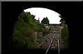
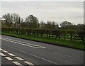
3
Kemble Tunnel
Looking towards the northern portal of the 355 metre long Kemble Tunnel
from Station Road. Kemble railway station is about 70 metres behind the camera.
Image: © Jaggery
Taken: 14 Jun 2015
0.09 miles
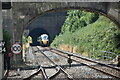
4
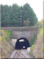
Kemble: the railway tunnel
Looking towards the north portal of the tunnel from Station Road.
Image: © Chris Downer
Taken: 13 Nov 2012
0.10 miles
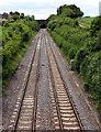
7
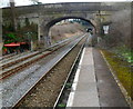
Kemble Tunnel portal viewed from Kemble railway station
This view from platform 2 through Station Road bridge shows the distant northern portal of the 409 yard (374m) long Kemble Tunnel. The portal is 275 metres from the bridge.
Image: © Jaggery
Taken: 18 Mar 2012
0.11 miles
8
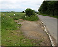
Gate to a field which may become the new Kemble railway station car park
On the corner of the A429 and Station Road. See http://www.geograph.org.uk/photo/4524594 for details.
Image: © Jaggery
Taken: 14 Jun 2015
0.12 miles
9
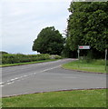
This way to Kemble railway station
A sign on the corner of the A429 points north along Station Road.
Image: © Jaggery
Taken: 14 Jun 2015
0.12 miles
10
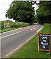
Oops you missed us, Tavern Inn, Kemble
If you wanted to go to the Tavern Inn http://www.geograph.org.uk/photo/2856007 this board tells you that you've missed the Station Road
turning a few metres behind the camera. Ahead, the 40mph speed limit on the A429 increases to 50.
Image: © Jaggery
Taken: 14 Jun 2015
0.13 miles