IMAGES TAKEN NEAR TO
The Twenties, CIRENCESTER, GL7 6ES
Introduction
This page details the photographs taken nearby to The Twenties, GL7 6ES by members of the Geograph project.
The Geograph project started in 2005 with the aim of publishing, organising and preserving representative images for every square kilometre of Great Britain, Ireland and the Isle of Man.

There are currently over 7.5m images from over14,400 individuals and you can help contribute to the project by visiting https://www.geograph.org.uk
Image Map
Images are licensed for reuse under creativecommons.org/licenses/by-sa/2.0
Notes
- Clicking on the map will re-center to the selected point.
- The higher the marker number, the further away the image location is from the centre of the postcode.
Image Listing (60 Images Found)
Images are licensed for reuse under creativecommons.org/licenses/by-sa/2.0
Image
Details
Distance
1
Old lock, Thames and Severn Canal, Siddington
The water seen in this image from a few months earlier https://www.geograph.org.uk/photo/4778770 has dried up.
Image: © Brian Robert Marshall
Taken: 16 Jul 2016
0.07 miles
2
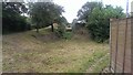
Remains of the M&SWJR Bridge across the Thames & Severn Canal at Siddington
The bridge carrying the Midland and South-Western Junction Railway across the Thames and Severn Canal between Siddington Third Lock and Siddington Lower Lock has been demolished. Siddington Third Lock can be seen in the distance. http://www.pikelock.co.uk/canal/t&scanal/siddington/siddington.html https://en.wikipedia.org/wiki/Thames_and_Severn_Canal http://www.cotswoldcanals.com/pages/locks-bridges-structures/bridges-and-buildings.php
Image: © Vieve Forward
Taken: 29 Dec 2015
0.07 miles
3
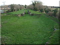
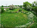
Siddington Locks
Looking up Siddington Locks with the chambers of locks 2 & 3 visible in the picture. Much work has been undertaken here in recent years to clear the undergrowth and the site is now a pleasant local amenity. The chambers appear to be in reasonable condition prior to further restoration work. Compare with Image
Image: © David Stowell
Taken: 5 Nov 2008
0.08 miles
5
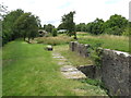
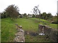
Former canal lock at Siddington
The remains of a lock on the former Thames & Severn Canal at Siddington, in Gloucestershire.
The Thames & Severn Way long distance path passes along the grass to the left of the former lock.
Image: © Malc McDonald
Taken: 11 Jul 2020
0.08 miles
6
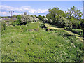
Siddington Locks, Thames and Severn Canal
This is image shows the view looking east from the stone road bridge which crosses this section of disused, but soon to be restored canal.
Image: © Peter Wasp
Taken: 30 May 2006
0.08 miles
7
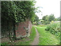
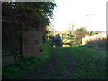
Remains of a railway bridge, Siddington
The brick wall is the remains of a bridge which carried a railway over the Thames & Severn Canal at Siddington in Gloucestershire. Neither the railway nor the canal is still in existence.
The path forms part of the Thames & Severn Way long distance path.
Image: © Malc McDonald
Taken: 11 Jul 2020
0.09 miles
8
Siddington locks from Upper Siddington Bridge, Thames and Severn Canal
Siddington Second Lock (nearest) and Siddington Third Lock, seen from Upper Siddington Bridge, Thames and Severn Canal. https://en.wikipedia.org/wiki/Thames_and_Severn_Canal http://www.cotswoldcanals.com/pages/locks-bridges-structures/bridges-and-buildings.php http://www.pikelock.co.uk/canal/t&scanal/siddington/siddington.html
Image: © Vieve Forward
Taken: 29 Dec 2015
0.09 miles
9
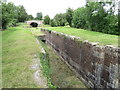
Former canal lock at Siddington
The remains of a lock on the former Thames & Severn Canal at Siddington, near Cirencester in Gloucestershire.
The Thames and Severn Way passes along the grass to the left of the former lock.
Image: © Malc McDonald
Taken: 11 Jul 2020
0.10 miles
10
The Thames and Severn canal, west of Siddington
Judging from its size it would appear that this was once a canal basin. The remains of a lock can be seen just beyond it and in more detail here Image
Image: © Brian Robert Marshall
Taken: 26 May 2010
0.10 miles