
IMAGES TAKEN NEAR TO
Oaksey Road, CIRENCESTER, GL7 6EA
Introduction
This page details the photographs taken nearby to Oaksey Road, GL7 6EA by members of the Geograph project.
The Geograph project started in 2005 with the aim of publishing, organising and preserving representative images for every square kilometre of Great Britain, Ireland and the Isle of Man.

There are currently over 7.5m images from over14,400 individuals and you can help contribute to the project by visiting https://www.geograph.org.uk
Image Map
Images are licensed for reuse under creativecommons.org/licenses/by-sa/2.0
Notes
- Clicking on the map will re-center to the selected point.
- The higher the marker number, the further away the image location is from the centre of the postcode.
Image Listing (9 Images Found)
Images are licensed for reuse under creativecommons.org/licenses/by-sa/2.0
Image
Details
Distance
1
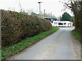
The road to the Somerford Keynes road, south of Poole Keynes
The Somerford Keynes road is visible beyond the 'T' junction. Beyond that is the Goodman Bros auto-dealer. I'm not sure if the firm is still trading as their website is broken.
Image: © Brian Robert Marshall
Taken: 29 Mar 2011
0.04 miles
2
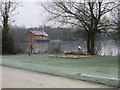
View of Friday Island in the Cotswolds Water Park
At 40 square miles the Cotswold Water Park is approximately the same size as the Island of Jersey. It is that part of the Upper Thames catchment in North Wiltshire & South Gloucestershire which has been subjected to over 50 years of sand & gravel extraction.
Image: © Nick Smith
Taken: 4 Jan 2009
0.07 miles
3
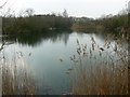
Lake near the road to Poole Keynes
This lake has no name and is separated from the nearby Neigh Bridge Country Park by the road from the Somerford Keynes road to Poole Keynes. It is another one of the innumerable lakes all round these part.
Image: © Brian Robert Marshall
Taken: 29 Mar 2011
0.09 miles
4
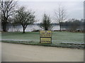
Friday Island, Cotswolds Water Park
At 40 square miles the Cotswold Water Park is approximately the same size as the Island of Jersey. It is that part of the Upper Thames catchment in North Wiltshire & South Gloucestershire which has been subjected to over 50 years of sand & gravel extraction.
http://www.waterpark.org/leisure/what-is-the-cotswold-water-park.html
Image: © Nick Smith
Taken: 4 Jan 2009
0.11 miles
5
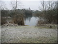
One of the lakes at Cotswolds Water Park
The Cotswold Water Park is an area of countryside set on the border between Wiltshire and Gloucestershire. More than 140 lakes, created through gravel extraction, provide the setting for activities, accommodation and attractions.
http://www.waterpark.org/leisure/what-is-the-cotswold-water-park.html
Image: © Nick Smith
Taken: 4 Jan 2009
0.13 miles
6
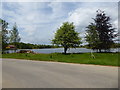
Friday Island resort
There are log cabins for hire on the edge of the lake in this private resort. It is named after the island in the middle of the lake, which I think can just be seen to the right behind the tree. A Palaeolithic handaxe was found when digging this lake, which is a former gravel pit. http://www.pastscape.org.uk/hob.aspx?hob_id=216748&sort=2&rational=m&recordsperpage=10&maplat=51.70949000&maplong=-1.99500300&mapisa=10000&mapist=pc&mapilo=-1.9950&mapila=51.7095&mapiloe=w&mapilan=n&mapios=SP003012&mapigrn=201246&mapigre=400345&mapipc=&p=83&move=n&nor=1667&recfc=0
Image: © Vieve Forward
Taken: 13 May 2018
0.16 miles
7
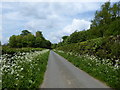
Lane near Friday Island
The Friday Island lake and log cabin holiday resort is private and cut off from the road by the hedge and ditch on the right, see Image
Image: © Vieve Forward
Taken: 13 May 2018
0.18 miles
9
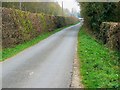
The road from Poole Keynes
Poole Keynes is behind the viewpoint. The narrow hedge-lined road terminates at a 'T' junction with the Somerford Keynes road just visible in the distance.
Image: © Brian Robert Marshall
Taken: 29 Mar 2011
0.23 miles