IMAGES TAKEN NEAR TO
Windmill Road, CIRENCESTER, GL7 6AL
Introduction
This page details the photographs taken nearby to Windmill Road, GL7 6AL by members of the Geograph project.
The Geograph project started in 2005 with the aim of publishing, organising and preserving representative images for every square kilometre of Great Britain, Ireland and the Isle of Man.

There are currently over 7.5m images from over14,400 individuals and you can help contribute to the project by visiting https://www.geograph.org.uk
Image Map
Images are licensed for reuse under creativecommons.org/licenses/by-sa/2.0
Notes
- Clicking on the map will re-center to the selected point.
- The higher the marker number, the further away the image location is from the centre of the postcode.
Image Listing (238 Images Found)
Images are licensed for reuse under creativecommons.org/licenses/by-sa/2.0
Image
Details
Distance
1
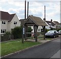
Windmill Road bus shelter, Kemble
Near Kemble Stores and post office. http://www.geograph.org.uk/photo/4525310
Image: © Jaggery
Taken: 14 Jun 2015
0.01 miles
2
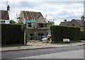
Windmill Road house construction, Kemble
Viewed in mid June 2015.
Image: © Jaggery
Taken: 14 Jun 2015
0.04 miles
3
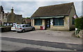
Kemble Stores and post office, Kemble
On the west side of Windmill Road, opposite Orchard Close.
Image: © Jaggery
Taken: 14 Jun 2015
0.04 miles
4
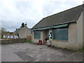
Kemble: the stores and post office
The village store is on Windmill Road, closed at the moment as it is shortly before 2 o'clock when it will reopen after lunch.
Image: © Chris Downer
Taken: 13 Nov 2012
0.05 miles
5
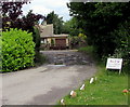
SLOW CHILDREN ANIMALS sign at the edge of Windmill Road, Kemble
Presumably this SLOW is an imperative verb rather than an adjective.
Image: © Jaggery
Taken: 14 Jun 2015
0.07 miles
6
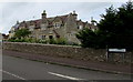
Station Road houses, Kemble
On the corner of Windmill Road. At the level of the upstairs window, embossed in the stonework in the middle of the facade, is a capital letter B with coronet above, showing that the houses were built as part of the estate of the Duke of Beaufort.
Image: © Jaggery
Taken: 4 Jun 2017
0.07 miles
7
Directions sign, Windmill Road, Kemble
The corner of Glebe Lane is on the left.
Image: © Jaggery
Taken: 14 Jun 2015
0.07 miles
8

Eastern end of Clayfurlong Grove, Kemble
Viewed from the corner of the A429, the main road through the village.
Image: © Jaggery
Taken: 4 Jun 2017
0.08 miles
9
Clayfurlong Grove, Kemble
Viewed from Windmill Road.
Image: © Jaggery
Taken: 14 Jun 2015
0.08 miles
10
Old Manor Gardens, Kemble
Cul-de-sac of 21st century houses on the north side of Station Road near Kemble railway station.
Image: © Jaggery
Taken: 4 Jun 2017
0.08 miles