IMAGES TAKEN NEAR TO
Mill Close, CIRENCESTER, GL7 5XP
Introduction
This page details the photographs taken nearby to Mill Close, GL7 5XP by members of the Geograph project.
The Geograph project started in 2005 with the aim of publishing, organising and preserving representative images for every square kilometre of Great Britain, Ireland and the Isle of Man.

There are currently over 7.5m images from over14,400 individuals and you can help contribute to the project by visiting https://www.geograph.org.uk
Image Map
Images are licensed for reuse under creativecommons.org/licenses/by-sa/2.0
Notes
- Clicking on the map will re-center to the selected point.
- The higher the marker number, the further away the image location is from the centre of the postcode.
Image Listing (119 Images Found)
Images are licensed for reuse under creativecommons.org/licenses/by-sa/2.0
Image
Details
Distance
1
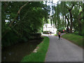
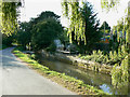
Bow-Wow, South Cerney
Bow-Wow lane looking towards a footbridge over the River Churn (on the left), another over the mill stream (on the right), and Lower Mill itself. http://www.cotswold.gov.uk/media/250970/south-cerney-ca-statement.pdf
Image: © Vieve Forward
Taken: 21 Jul 2014
0.04 miles
2
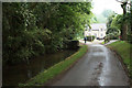
Bow-wow, South Cerney
An oddly named road next to the River Churn.
Image: © Bill Boaden
Taken: 26 May 2018
0.04 miles
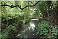
3
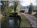
River Churn
River Churn by Bow Wow at the South Cerney mill
Image: © Shaun Ferguson
Taken: 25 Feb 2012
0.05 miles
5
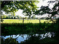
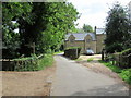
Mill stream, Bow Wow, South Cerney
The mill stream takes water from the River Churn http://www.geograph.org.uk/photo/1518004 near the entrance to Bow Wow to the right and rejoins the river about 250 metres east of here (to the left). The properties in the distance are in Station Road.
Image: © Brian Robert Marshall
Taken: 1 Oct 2009
0.07 miles
7
Part of the River Churn near South Cerney
A subsidiary course of this tributary of the River Thames, which will rejoin the main course shortly.
Image: © Bill Boaden
Taken: 26 May 2018
0.10 miles
8
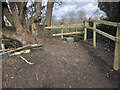
Stone stile, to South Cerney
On Gloucestershire footpath BSC15 adjacent to the churchyard wall.
Image: © Fay Britton
Taken: 11 Mar 2021
0.12 miles
9
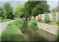
Bow Wow and the River Churn, South Cerney
This charming little thoroughfare is part of a conservation area. There is much information is this pdf from the local planning authority http://www.cotswold.gov.uk/media/documents/Heritage/Design%20Guides/SouthCerney.pdf
Image: © Brian Robert Marshall
Taken: 1 Oct 2009
0.13 miles
10
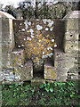
Stone stile, to South Cerney
On Gloucestershire footpath BSC15 the stile which indicates the registered footpath. This view looks NE from the graveyard. The view to the graveyard is Image
Image: © Fay Britton
Taken: 11 Mar 2021
0.13 miles