IMAGES TAKEN NEAR TO
Down Ampney, CIRENCESTER, GL7 5QT
Introduction
This page details the photographs taken nearby to GL7 5QT by members of the Geograph project.
The Geograph project started in 2005 with the aim of publishing, organising and preserving representative images for every square kilometre of Great Britain, Ireland and the Isle of Man.

There are currently over 7.5m images from over14,400 individuals and you can help contribute to the project by visiting https://www.geograph.org.uk
Image Map
Images are licensed for reuse under creativecommons.org/licenses/by-sa/2.0
Notes
- Clicking on the map will re-center to the selected point.
- The higher the marker number, the further away the image location is from the centre of the postcode.
Image Listing (4 Images Found)
Images are licensed for reuse under creativecommons.org/licenses/by-sa/2.0
Image
Details
Distance
1
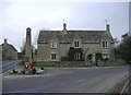
War memorial, Down Ampney
Dedicated to the fallen of 1914-18.
Image: © Roger Cornfoot
Taken: 5 Feb 2007
0.06 miles
3
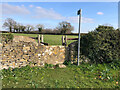
Stone Stile, Down Ampney
On Gloucestershire footpath BDA8 looking West from the road. The view from the field is Image
Image: © Jayne Tovey
Taken: 29 Sep 2022
0.12 miles
4
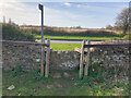
Stone Stile, Down Ampney
On Gloucestershire footpath BDA8 looking West to the road. The view to the field is Image
Image: © Jayne Tovey
Taken: 29 Sep 2022
0.12 miles