IMAGES TAKEN NEAR TO
Down Ampney, CIRENCESTER, GL7 5QQ
Introduction
This page details the photographs taken nearby to GL7 5QQ by members of the Geograph project.
The Geograph project started in 2005 with the aim of publishing, organising and preserving representative images for every square kilometre of Great Britain, Ireland and the Isle of Man.

There are currently over 7.5m images from over14,400 individuals and you can help contribute to the project by visiting https://www.geograph.org.uk
Image Map
Images are licensed for reuse under creativecommons.org/licenses/by-sa/2.0
Notes
- Clicking on the map will re-center to the selected point.
- The higher the marker number, the further away the image location is from the centre of the postcode.
Image Listing (18 Images Found)
Images are licensed for reuse under creativecommons.org/licenses/by-sa/2.0
Image
Details
Distance
1
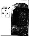
Old Milestone
Metal plate attached to stone post by the UC road (was A419), in parish of LATTON (NORTH WILTSHIRE District), Ermin Street, by Westfield Farm, by the road, on SW side of road. Cricklade iron plate Erected by the Cirencester & Cricklade turnpike trust in the 19th century.
Inscription reads:- : CIREN.R / 5 / CRICK.E / 2 / : : : . ; .
Listed.
Milestone Society National ID: WI_CICK05.
Image: © JM Weightmann
Taken: 1 Oct 2000
0.06 miles
2
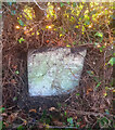
Old Milestone, Westfield Farm, Ermin Street
In the parish of Latton, on the SW side of Ermin Street (Roman Road).
Erected by the Cirencester and Cricklade Turnpike Trust in the 19ᵗʰ century.
An image of the original plate can be seen at Image
Inscription (was): Cirencᴿ. / 5 / Crickᴱ. / 2
Milestone Society National ID: GL_CICK05
Image: © Tom Blanden
Taken: 5 Dec 2022
0.06 miles
3
Road towards Down Ampney from near old A417
Image: © Peter Watkins
Taken: 2 Dec 2006
0.15 miles
4
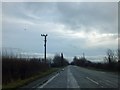
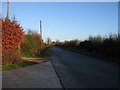
Staggered crossroads on old route of A419
When the A419 was made a dual carriageway, this stretch was by-passed. As is evident, the road runs in a straight line, following the Roman Ermin Way (Ermine Street). The road on the right leads to Cerney Wick and on the left is the way to Down Ampney.
Image: © David Smith
Taken: 28 Dec 2012
0.17 miles
6
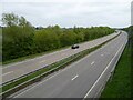
The A419 passing Cerney Wick
The A419 follows the route of Ermin Way, a Roman Road at this point. The road was dualled some years ago, the old A419 runs on a parallel course nearby.
Image: © Philip Halling
Taken: 3 May 2022
0.19 miles
7
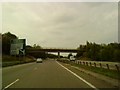
Cerney Wick Road Bridge
Bridge over the A419 in Cerney Wick.
Image: © Wayland Smith
Taken: 25 May 2020
0.19 miles
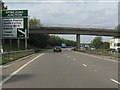
8

A419 from under overbridge near Westfield Farm
Image: © John Firth
Taken: 1 Sep 2017
0.19 miles
9
A419 - minor road overbridge near Cerney Wick
Image: © J Whatley
Taken: 22 Sep 2010
0.20 miles