IMAGES TAKEN NEAR TO
Bibury, CIRENCESTER, GL7 5PB
Introduction
This page details the photographs taken nearby to GL7 5PB by members of the Geograph project.
The Geograph project started in 2005 with the aim of publishing, organising and preserving representative images for every square kilometre of Great Britain, Ireland and the Isle of Man.

There are currently over 7.5m images from over14,400 individuals and you can help contribute to the project by visiting https://www.geograph.org.uk
Image Map
Images are licensed for reuse under creativecommons.org/licenses/by-sa/2.0
Notes
- Clicking on the map will re-center to the selected point.
- The higher the marker number, the further away the image location is from the centre of the postcode.
Image Listing (14 Images Found)
Images are licensed for reuse under creativecommons.org/licenses/by-sa/2.0
Image
Details
Distance
1
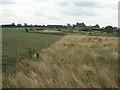
Bibury Farm from Hale Barn
This photo doesn't quite do full justice to the towering concrete construction that seems to dominate the landscape when not seen through the camera.
Image: © Katy Walters
Taken: 15 Aug 2006
0.02 miles
2
![A circular walk around Bibury and Ablington [42]](https://s2.geograph.org.uk/geophotos/07/49/23/7492358_1bc42dfc_120x120.jpg)
A circular walk around Bibury and Ablington [42]
From the bridleway, Bibury Farm is seen across the fields.
The walk starts at Arlington Corner and follows a footpath to Ablington, where the River Coln is crossed, and then a byway northeast to Saltway Barn. Another byway, the historic Salt Way, is then followed southeast before a right turn onto a bridleway which runs south past Hale Barn to Bibury. The River Coln is recrossed at Bibury Mill and a footpath is then followed back to the starting point. Just over 5 miles.
Image: © Michael Dibb
Taken: 10 May 2023
0.06 miles
4
![A circular walk around Bibury and Ablington [47]](https://s3.geograph.org.uk/geophotos/07/49/23/7492387_ae387348_120x120.jpg)
A circular walk around Bibury and Ablington [47]
The bridleway runs along the access driveway to Hale Barn.
The walk starts at Arlington Corner and follows a footpath to Ablington, where the River Coln is crossed, and then a byway northeast to Saltway Barn. Another byway, the historic Salt Way, is then followed southeast before a right turn onto a bridleway which runs south past Hale Barn to Bibury. The River Coln is recrossed at Bibury Mill and a footpath is then followed back to the starting point. Just over 5 miles.
Image: © Michael Dibb
Taken: 10 May 2023
0.15 miles
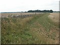
5
![A circular walk around Bibury and Ablington [48]](https://s3.geograph.org.uk/geophotos/07/49/24/7492403_67f1b124_120x120.jpg)
A circular walk around Bibury and Ablington [48]
The bridleway now runs on this track. The track ascends and the trees on the skyline houses a covered reservoir.
The walk starts at Arlington Corner and follows a footpath to Ablington, where the River Coln is crossed, and then a byway northeast to Saltway Barn. Another byway, the historic Salt Way, is then followed southeast before a right turn onto a bridleway which runs south past Hale Barn to Bibury. The River Coln is recrossed at Bibury Mill and a footpath is then followed back to the starting point. Just over 5 miles.
Image: © Michael Dibb
Taken: 10 May 2023
0.16 miles
6
![A circular walk around Bibury and Ablington [49]](https://s0.geograph.org.uk/geophotos/07/49/24/7492408_728014bf_120x120.jpg)
A circular walk around Bibury and Ablington [49]
Alongside the track, on top of the hill, is this covered reservoir, part of the Thames Water infrastructure.
The walk starts at Arlington Corner and follows a footpath to Ablington, where the River Coln is crossed, and then a byway northeast to Saltway Barn. Another byway, the historic Salt Way, is then followed southeast before a right turn onto a bridleway which runs south past Hale Barn to Bibury. The River Coln is recrossed at Bibury Mill and a footpath is then followed back to the starting point. Just over 5 miles.
Image: © Michael Dibb
Taken: 10 May 2023
0.17 miles
7
![A circular walk around Bibury and Ablington [46]](https://s2.geograph.org.uk/geophotos/07/49/23/7492382_0ca42d9c_120x120.jpg)
A circular walk around Bibury and Ablington [46]
The pond is alongside the bridleway and near Hale Barn.
The walk starts at Arlington Corner and follows a footpath to Ablington, where the River Coln is crossed, and then a byway northeast to Saltway Barn. Another byway, the historic Salt Way, is then followed southeast before a right turn onto a bridleway which runs south past Hale Barn to Bibury. The River Coln is recrossed at Bibury Mill and a footpath is then followed back to the starting point. Just over 5 miles.
Image: © Michael Dibb
Taken: 10 May 2023
0.21 miles
9
![A circular walk around Bibury and Ablington [45]](https://s0.geograph.org.uk/geophotos/07/49/23/7492380_30f44e01_120x120.jpg)
A circular walk around Bibury and Ablington [45]
A couple of local residents on the pond near Hale Barn.
The walk starts at Arlington Corner and follows a footpath to Ablington, where the River Coln is crossed, and then a byway northeast to Saltway Barn. Another byway, the historic Salt Way, is then followed southeast before a right turn onto a bridleway which runs south past Hale Barn to Bibury. The River Coln is recrossed at Bibury Mill and a footpath is then followed back to the starting point. Just over 5 miles.
Image: © Michael Dibb
Taken: 10 May 2023
0.22 miles
10
![A circular walk around Bibury and Ablington [50]](https://s3.geograph.org.uk/geophotos/07/49/24/7492415_89a34323_120x120.jpg)
A circular walk around Bibury and Ablington [50]
Part of the infrastructure of the reservoir.
The walk starts at Arlington Corner and follows a footpath to Ablington, where the River Coln is crossed, and then a byway northeast to Saltway Barn. Another byway, the historic Salt Way, is then followed southeast before a right turn onto a bridleway which runs south past Hale Barn to Bibury. The River Coln is recrossed at Bibury Mill and a footpath is then followed back to the starting point. Just over 5 miles.
Image: © Michael Dibb
Taken: 10 May 2023
0.22 miles