IMAGES TAKEN NEAR TO
Spine Road, CIRENCESTER, GL7 5LT
Introduction
This page details the photographs taken nearby to Spine Road, GL7 5LT by members of the Geograph project.
The Geograph project started in 2005 with the aim of publishing, organising and preserving representative images for every square kilometre of Great Britain, Ireland and the Isle of Man.

There are currently over 7.5m images from over14,400 individuals and you can help contribute to the project by visiting https://www.geograph.org.uk
Image Map
Images are licensed for reuse under creativecommons.org/licenses/by-sa/2.0
Notes
- Clicking on the map will re-center to the selected point.
- The higher the marker number, the further away the image location is from the centre of the postcode.
Image Listing (36 Images Found)
Images are licensed for reuse under creativecommons.org/licenses/by-sa/2.0
Image
Details
Distance
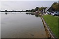
1
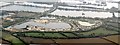
Watermark Lakes
Isis Lake, Windrush Lake, Spring Lake.
Now considerably more development on the left hand portion of the picture
Image: © Peter Randall-Cook
Taken: Unknown
0.07 miles
2
South Cerney Education Centre
South Cerney Education Centre looking back to the Spine Road. Lake 12
Image: © Colin Manton
Taken: 31 Aug 2013
0.09 miles
3
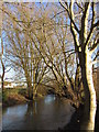
A swollen River Churn near South Cerney
Image: © Gareth James
Taken: 26 Dec 2013
0.13 miles
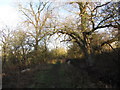
7
![Wildmoorway Lane [5]](https://s0.geograph.org.uk/geophotos/05/91/10/5911020_6a297c43_120x120.jpg)
Wildmoorway Lane [5]
The lane continues towards South Cerney.
The lane, a public footpath, runs from Wildmoorway Lock on the Thames & Severn Canal to Station Road in South Cerney. With many of the Rights of Way being between lakes and with much 'exclusive' housing development, the footpaths/bridleways/cycleways are mostly narrow and enclosed by fencing although the way is a little wider at this point.
Image: © Michael Dibb
Taken: 11 Sep 2018
0.13 miles
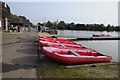
8
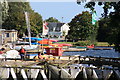
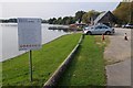
Water sports centre, South Cerney
Water sports centre and lake at South Cerney.
Image: © Philip Halling
Taken: 4 Oct 2015
0.13 miles
9
![Wildmoorway Lane [4]](https://s3.geograph.org.uk/geophotos/05/91/10/5911019_0689203b_120x120.jpg)
Wildmoorway Lane [4]
The lane continues towards South Cerney.
The lane, a public footpath, runs from Wildmoorway Lock on the Thames & Severn Canal to Station Road in South Cerney. With many of the Rights of Way being between lakes and with much 'exclusive' housing development, the footpaths/bridleways/cycleways are mostly narrow and enclosed by fencing.
Image: © Michael Dibb
Taken: 11 Sep 2018
0.14 miles
10
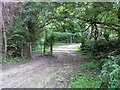
Gate across the lane
Beyond the gate the lane is wider and driveable.
The lane, a public footpath, runs from Wildmoorway Lock on the Thames & Severn Canal to Station Road in South Cerney. With many of the Rights of Way being between lakes and with much 'exclusive' housing development, the footpaths/bridleways/cycleways are mostly narrow and enclosed by fencing.
Image: © Michael Dibb
Taken: 11 Sep 2018
0.14 miles