IMAGES TAKEN NEAR TO
Washpool Lane, FAIRFORD, GL7 4NJ
Introduction
This page details the photographs taken nearby to Washpool Lane, GL7 4NJ by members of the Geograph project.
The Geograph project started in 2005 with the aim of publishing, organising and preserving representative images for every square kilometre of Great Britain, Ireland and the Isle of Man.

There are currently over 7.5m images from over14,400 individuals and you can help contribute to the project by visiting https://www.geograph.org.uk
Image Map
Images are licensed for reuse under creativecommons.org/licenses/by-sa/2.0
Notes
- Clicking on the map will re-center to the selected point.
- The higher the marker number, the further away the image location is from the centre of the postcode.
Image Listing (11 Images Found)
Images are licensed for reuse under creativecommons.org/licenses/by-sa/2.0
Image
Details
Distance
1
Gate, RAF Fairford
The gate protects some sort of infrastructure associated with the main air base behind the viewpoint. The brown sign prohibits the use of tobacco in the area behind it.
Image: © Brian Robert Marshall
Taken: 1 Apr 2014
0.10 miles
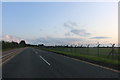
2
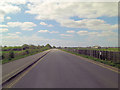
Road from Whelford to Kempsford
Running alongside RAF Fairford air base.
Image: © andrew auger
Taken: 1 Nov 2009
0.10 miles
3
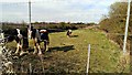
Horses in a narrow field, Whelford
The horses look too small to be fully grown but the large hooves suggest that they are carthorses of some sort. Quite placid.
Image: © Brian Robert Marshall
Taken: 1 Apr 2014
0.12 miles
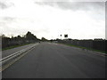
4
Whelford Road passes through RAF Fairford
Image: © Stuart Logan
Taken: 13 Apr 2014
0.12 miles
5
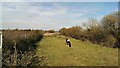
Strip of land, Whelford
The narrow strip of land lies between the Whelford to Kempsford road and part of RAF Fairford. It is currently home to a small number of what look like young carthorses.
Image: © Brian Robert Marshall
Taken: 1 Apr 2014
0.13 miles
6
The road to Whelford
The road passes RAF Fairford.
Image: © Steve Daniels
Taken: 30 Mar 2014
0.13 miles
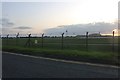
7
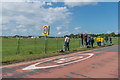
Planespotting
Plane spotters on the road that leads under the approach to the runway at RAF Fairford.
Image: © Ian Capper
Taken: 11 Jun 2017
0.13 miles
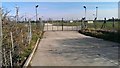
8
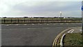
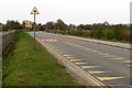
View across the Whelford to Kempsford Road
Whelford is to the right. Beyond the fence is the eastern end of Runway 27 of RAF Fairford. Most of the time there are no planes in evidence. That all changes for a few days every July when the much-acclaimed Royal International Air Tattoo takes place. A grand day out http://www.geograph.org.uk/search.php?i=47984963&displayclass=bigger
Image: © Brian Robert Marshall
Taken: 1 Apr 2014
0.15 miles