IMAGES TAKEN NEAR TO
Warwick Close, FAIRFORD, GL7 4LR
Introduction
This page details the photographs taken nearby to Warwick Close, GL7 4LR by members of the Geograph project.
The Geograph project started in 2005 with the aim of publishing, organising and preserving representative images for every square kilometre of Great Britain, Ireland and the Isle of Man.

There are currently over 7.5m images from over14,400 individuals and you can help contribute to the project by visiting https://www.geograph.org.uk
Image Map
Images are licensed for reuse under creativecommons.org/licenses/by-sa/2.0
Notes
- Clicking on the map will re-center to the selected point.
- The higher the marker number, the further away the image location is from the centre of the postcode.
Image Listing (8 Images Found)
Images are licensed for reuse under creativecommons.org/licenses/by-sa/2.0
Image
Details
Distance
1
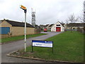
Fairford Fire Station
Fairford station has just one engine, and was called out 87 times in 2005.
The view is across the gridline to get all the grounds in shot.
Image: © Jonathan Billinger
Taken: 3 Jan 2007
0.10 miles
2
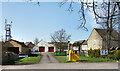
Fairford Fire Station
The station building is set back from Hatherop Road and is in SP1501.
It has been extended since originally Geographed in 2007 when it only had one door.
Image
Image: © Des Blenkinsopp
Taken: 30 Mar 2021
0.13 miles
3
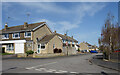
Aldsworth Close, Fairford
Suburban housing on the eastern edge of Fairford.
Aldsworth is a village about 8 kms north of here.
Image: © Des Blenkinsopp
Taken: 30 Mar 2021
0.16 miles
4
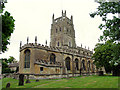
St Mary's Fairford
A view of the church from the north west.
Image: © Pam Brophy
Taken: 28 Jun 2005
0.20 miles
5
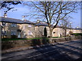
Victory Villas, London Road, Fairford
Stone-built council houses, completed in 1921.
Image: © Vieve Forward
Taken: 1 Mar 2012
0.20 miles
6
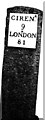
Old Milestone by the A417, London Road, Fairford parish
Metal plate attached to stone post by the A417, in parish of FAIRFORD (COTSWOLD District), East of entrance to football ground, set in wall, on South side of road. Cirencester iron plate, erected by the Cirencester to St John's Bridge turnpike trust in the 19th century.
More recent image is Image
Inscription reads:-
CIREN.R
9
LONDON
81
Carved benchmark on mid lower front.
Milestone Society National ID: GL_LG81.
Image: © JM Weightmann
Taken: 1 Feb 2000
0.23 miles
7
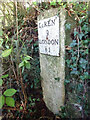
Old Milestone, A417
Old Milestone by the A417, London Road, Fairford parish
Metal plate attached to stone post by the A417, in parish of FAIRFORD (COTSWOLD District), East of entrance to football ground, set in wall, on South side of road. Cirencester iron plate, erected by the Cirencester to St John's Bridge turnpike trust in the 19th century. Carved, weathered, Benchmark representing 85.9m Above Sea Level (1965) or 282.5ft (86.1m 1901).
Inscription reads: CIRENᴿ / 9 / LONDON / 81
Milestone Society National ID: GL_LG81
Image: © Mr Red
Taken: 9 Oct 2021
0.23 miles
8
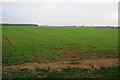
Winter cereals, Fairford
A field of winter cereals on the eastern edge of Fairford.
Image: © Philip Halling
Taken: 19 Nov 2011
0.24 miles