IMAGES TAKEN NEAR TO
Whelford, FAIRFORD, GL7 4DY
Introduction
This page details the photographs taken nearby to GL7 4DY by members of the Geograph project.
The Geograph project started in 2005 with the aim of publishing, organising and preserving representative images for every square kilometre of Great Britain, Ireland and the Isle of Man.

There are currently over 7.5m images from over14,400 individuals and you can help contribute to the project by visiting https://www.geograph.org.uk
Image Map
Images are licensed for reuse under creativecommons.org/licenses/by-sa/2.0
Notes
- Clicking on the map will re-center to the selected point.
- The higher the marker number, the further away the image location is from the centre of the postcode.
Image Listing (47 Images Found)
Images are licensed for reuse under creativecommons.org/licenses/by-sa/2.0
Image
Details
Distance
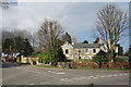
1
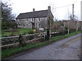
Townsend Farmhouse, Whelford
Grade II Listed late 18th century Cotswold stone farmhouse. http://www.britishlistedbuildings.co.uk/en-128960-townsend-farmhouse-kempsford-gloucesters
Image: © Vieve Forward
Taken: 7 Jan 2013
0.00 miles
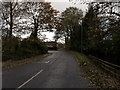
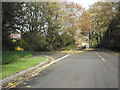
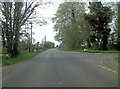
4
The road through Whelford
The turning for RAF Fairford is on the left.
Image: © David Purchase
Taken: 18 Aug 2016
0.05 miles
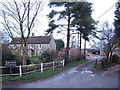
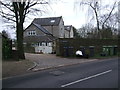
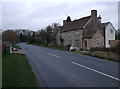
5
Pope's Court, Whelford
A large house in a small village.
Image: © Des Blenkinsopp
Taken: 8 Mar 2022
0.06 miles
7
Popes Court, Whelford
Flats in a converted house.
Image: © Vieve Forward
Taken: 7 Jan 2013
0.07 miles
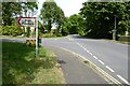
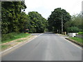
9
The turning to RAF Fairford in Whelford
Image: © Stuart Logan
Taken: 13 Apr 2014
0.08 miles
10
Millacre, Whelford
Cotswold stone cottage.
Image: © Vieve Forward
Taken: 7 Jan 2013
0.08 miles