IMAGES TAKEN NEAR TO
Horcott Road, FAIRFORD, GL7 4BX
Introduction
This page details the photographs taken nearby to Horcott Road, GL7 4BX by members of the Geograph project.
The Geograph project started in 2005 with the aim of publishing, organising and preserving representative images for every square kilometre of Great Britain, Ireland and the Isle of Man.

There are currently over 7.5m images from over14,400 individuals and you can help contribute to the project by visiting https://www.geograph.org.uk
Image Map
Images are licensed for reuse under creativecommons.org/licenses/by-sa/2.0
Notes
- Clicking on the map will re-center to the selected point.
- The higher the marker number, the further away the image location is from the centre of the postcode.
Image Listing (27 Images Found)
Images are licensed for reuse under creativecommons.org/licenses/by-sa/2.0
Image
Details
Distance
1
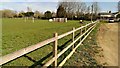
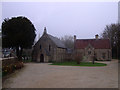
Sports pitch and car park, Horcott, Fairford
The pitch is a non-artificial pitch which could well provide facilities for various sports such as football. The purpose of the wall with holes in it eludes me.
Image: © Brian Robert Marshall
Taken: 1 Apr 2014
0.03 miles
2
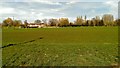
Sports pitch, Horcott, Fairford
Possibly this is a hockey pitch, or a football pitch for small people. It does not appear to be anything to do with Fairford Town FC who play at Cinder Lane in the town.
Image: © Brian Robert Marshall
Taken: 1 Apr 2014
0.05 miles
3
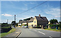
Houses on Horcott Road
Horcott is a residential neighbourhood separated from Fairford itself by the River Coln.
Image: © Des Blenkinsopp
Taken: 20 Jun 2022
0.07 miles
4
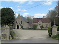
Church of St Thomas of Canterbury
This is a Grade II listed Roman Catholic church dating from 1845. It has English Heritage Building ID: 492166. Next door is a good example of a High Victorian Gothic style presbytery dating from two decades later and designed by Benjamin Bucknall. It is also Grade II listed but with English Heritage Building ID: 492565.
Image: © Stuart Logan
Taken: 13 Apr 2014
0.10 miles
5
Church of St. Thomas of Canterbury, Horcott
Grade II listed Catholic Parish Church of Saint Thomas of Canterbury, Horcott. http://www.britishlistedbuildings.co.uk/en-492166-roman-catholic-church-of-st-thomas-of-ca To the right of the church is the Grade II listed Presbytery. http://www.britishlistedbuildings.co.uk/en-492565-presbytery-of-church-of-st-thomas-of-can
Image: © Vieve Forward
Taken: 15 Mar 2012
0.10 miles
6
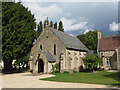
St Thomas of Canterbury church, Fairford
Image: © Gareth James
Taken: 9 Sep 2017
0.10 miles
7
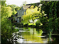
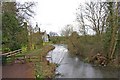
River Coln, Fairford
This is a downstream view of the river as it leads away out of the town towards its terminus a few kilometres away at Inglesham. The impressive property in the background is the imaginatively named 'Colnside', which, surprisingly, isn't listed.
Image: © Brian Robert Marshall
Taken: 18 Sep 2020
0.12 miles
8
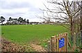
School playing fields, Fairford
The notice on the gate warns against unauthorised entry and states no dogs are allowed.
Image: © P L Chadwick
Taken: 11 Mar 2011
0.12 miles
9
River Coln, Fairford
A public footpath goes through the gate on the river's left bank. This runs alongside the river for a while, and can easily be made part of a circular walk. Photographed from Dilly's Bridge.
Image: © P L Chadwick
Taken: 11 Mar 2011
0.13 miles
10
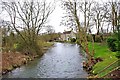
River Coln, Fairford
Another view of the river from Dilly's Bridge. The other channel of the river joins the main channel, just past the large tree on the left.
Image: © P L Chadwick
Taken: 11 Mar 2011
0.14 miles