IMAGES TAKEN NEAR TO
Manor Close, FAIRFORD, GL7 4BG
Introduction
This page details the photographs taken nearby to Manor Close, GL7 4BG by members of the Geograph project.
The Geograph project started in 2005 with the aim of publishing, organising and preserving representative images for every square kilometre of Great Britain, Ireland and the Isle of Man.

There are currently over 7.5m images from over14,400 individuals and you can help contribute to the project by visiting https://www.geograph.org.uk
Image Map
Images are licensed for reuse under creativecommons.org/licenses/by-sa/2.0
Notes
- Clicking on the map will re-center to the selected point.
- The higher the marker number, the further away the image location is from the centre of the postcode.
Image Listing (24 Images Found)
Images are licensed for reuse under creativecommons.org/licenses/by-sa/2.0
Image
Details
Distance
1
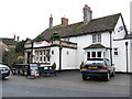
The Railway
This pub is about half a mile from the now demolished railway station, so travellers arriving in Fairford would come past this hostelry before getting to the town centre to the west.
Image: © Jonathan Billinger
Taken: 3 Jan 2007
0.07 miles
2
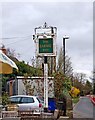
The Railway Inn (2) - sign, London Road, Fairford
It was Fairford's misfortune that it should be at the end of a minor single-track branch line, going to Oxford rather than Cirencester, Gloucester etc. and that the railway station should be located well out of the town's centre, and indeed out of the built-up area (as it then was) completely. So it is no surprise that it closed in 1962, after about 99 years service. The Railway Inn is a reminder of the days when Fairford had a railway. There are on this site some fascinating historical photos of the railway station, before and after closure, in this OS square Image
Image
Image: © P L Chadwick
Taken: 11 Mar 2011
0.09 miles
3
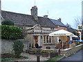
The Railway Inn (1), London Road, Fairford
One of the handful of surviving pubs in Fairford. Although the pub survives, the railway disappeared in the early 1960's. Fairford was at the end of a branch line from Oxford to Witney, and then from Witney via Lechlade to Fairford. The railway reached Fairford in 1863, and this pub was certainly trading as the Railway Inn by 1891. It was then owned by the North Wilts Brewery of Swindon, and the Landlord was Edward Cowley. On the stone arch above the entrance door is carved "The Railway".
Image
Image: © P L Chadwick
Taken: 11 Mar 2011
0.09 miles
4
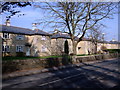
The Railway Inn
Cotswold stone pub, decorated with Christmas lights, on Fairford's London Road.
Image: © Colin Smith
Taken: 27 Dec 2007
0.09 miles
5
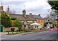
Victory Villas, London Road, Fairford
Stone-built council houses, completed in 1921.
Image: © Vieve Forward
Taken: 1 Mar 2012
0.09 miles
6
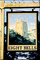
Eight Bells Pub Sign, Fairford, Gloucestershire 2002
Image: © Ray Bird
Taken: Unknown
0.12 miles
7
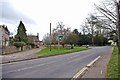
London Road (A417) near East End, Fairford
London Road is the main road through the small town of Fairford, and part of the A417. On the left in the distance, is the Eight Bells pub, with its predominantly blue sign. On the small green near the road, is another sign for the pub. The road coming in from the left, past this sign, is East End.
Image: © P L Chadwick
Taken: 11 Mar 2011
0.15 miles
8
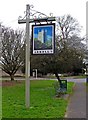
The Eight Bells (4) - sign, East End, Fairford
One of two signs for this pub, both slightly different. This one is on the small green near the pub, adjacent to London Road. This results in it being in the adjacent Ordnance Survey square to that containing the pub.
More photos:- Image
Image: © P L Chadwick
Taken: 11 Mar 2011
0.15 miles
9
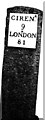
Old Milestone by the A417, London Road, Fairford parish
Metal plate attached to stone post by the A417, in parish of FAIRFORD (COTSWOLD District), East of entrance to football ground, set in wall, on South side of road. Cirencester iron plate, erected by the Cirencester to St John's Bridge turnpike trust in the 19th century.
More recent image is Image
Inscription reads:-
CIREN.R
9
LONDON
81
Carved benchmark on mid lower front.
Milestone Society National ID: GL_LG81.
Image: © JM Weightmann
Taken: 1 Feb 2000
0.15 miles
10
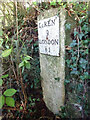
Old Milestone, A417
Old Milestone by the A417, London Road, Fairford parish
Metal plate attached to stone post by the A417, in parish of FAIRFORD (COTSWOLD District), East of entrance to football ground, set in wall, on South side of road. Cirencester iron plate, erected by the Cirencester to St John's Bridge turnpike trust in the 19th century. Carved, weathered, Benchmark representing 85.9m Above Sea Level (1965) or 282.5ft (86.1m 1901).
Inscription reads: CIRENᴿ / 9 / LONDON / 81
Milestone Society National ID: GL_LG81
Image: © Mr Red
Taken: 9 Oct 2021
0.15 miles