IMAGES TAKEN NEAR TO
Swansfield, LECHLADE, GL7 3SF
Introduction
This page details the photographs taken nearby to Swansfield, GL7 3SF by members of the Geograph project.
The Geograph project started in 2005 with the aim of publishing, organising and preserving representative images for every square kilometre of Great Britain, Ireland and the Isle of Man.

There are currently over 7.5m images from over14,400 individuals and you can help contribute to the project by visiting https://www.geograph.org.uk
Image Map
Images are licensed for reuse under creativecommons.org/licenses/by-sa/2.0
Notes
- Clicking on the map will re-center to the selected point.
- The higher the marker number, the further away the image location is from the centre of the postcode.
Image Listing (17 Images Found)
Images are licensed for reuse under creativecommons.org/licenses/by-sa/2.0
Image
Details
Distance
1
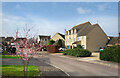
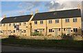
Perrinsfield, Lechlade
Part of a new housing development on the north side of Lechlade.
Image: © Des Blenkinsopp
Taken: 8 Mar 2022
0.05 miles
2
Site of former Lechlade station, 1999
View eastward, just off the A361 (Swindon - Banbury) road, towards Witney and Oxford on the course of the ex-GWR Oxford - Witney - Fairford branch, closed since 18/6/62 - except goods to Witney until 5/1/70. (Cf. Image]).
Image: © Ben Brooksbank
Taken: 2 Sep 1999
0.09 miles
3
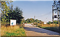
Lechlade railway station (site), Gloucestershire
Opened in 1873 by the East Gloucestershire Railway, later part of the Great Western Railway, on the line from Oxford to Fairford, this station closed in 1962.
View east from the former road bridge towards Kelmscott & Langford and Oxford. The view is taken from a few metres further back than Image some 69 years previously. The station building would probably have been behind the left-most house.
Image: © Nigel Thompson
Taken: 17 Apr 2019
0.10 miles
4
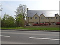
New houses on Station Road, Lechlade
These were built by Redrow in 2015
Image: © David Howard
Taken: 10 Sep 2019
0.11 miles
5
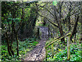
Entrance to Amey Richardson Nature Reserve, Lechlade
The reserve is in two sections. This image shows the entrance to the southern part. As might be discerned from the reserve's name, this was once a quarry.
Image: © Brian Robert Marshall
Taken: 25 Mar 2022
0.14 miles
6
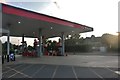
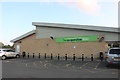
Petrol station on Station Road, Lechlade
One of the many Station Roads with no railway station
Image: © David Howard
Taken: 10 Aug 2019
0.15 miles
7

Lechlade station, 1950
View from the road bridge, westward towards Fairford on the branch line from Oxford via Witney, closed 18/6/62.
Image: © Walter Dendy, deceased
Taken: 24 Sep 1950
0.15 miles
8

Roundabout on the northern edge of Lechlade
Image: © andrew auger
Taken: 5 Sep 2009
0.17 miles
9
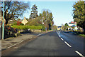
A361 Station Road, Lechlade
Towards Burford and where the station was, about 300 m ahead. The line closed in 1962.
Image: © Robin Webster
Taken: 19 Jan 2020
0.17 miles