IMAGES TAKEN NEAR TO
Newfound Reach, Coln Waters, LECHLADE, GL7 3FU
Introduction
This page details the photographs taken nearby to Newfound Reach, Coln Waters, GL7 3FU by members of the Geograph project.
The Geograph project started in 2005 with the aim of publishing, organising and preserving representative images for every square kilometre of Great Britain, Ireland and the Isle of Man.

There are currently over 7.5m images from over14,400 individuals and you can help contribute to the project by visiting https://www.geograph.org.uk
Image Map
Images are licensed for reuse under creativecommons.org/licenses/by-sa/2.0
Notes
- Clicking on the map will re-center to the selected point.
- The higher the marker number, the further away the image location is from the centre of the postcode.
Image Listing (10 Images Found)
Images are licensed for reuse under creativecommons.org/licenses/by-sa/2.0
Image
Details
Distance
1
![A figure of eight walk from Lechlade-on-Thames [30]](https://s3.geograph.org.uk/geophotos/07/26/52/7265215_057025a5_120x120.jpg)
A figure of eight walk from Lechlade-on-Thames [30]
Some of the recently built houses are somewhat away from the waterfront.
After leaving Lechlade, the route joins the long distance Thames and Severn Way and passes the southern edge of Bowmoor Lake. Turning north, and looping around the northern edge of the lake, the Thames and Severn Way is re-joined and followed to the banks of the River Thames and back to Lechlade. Slightly over 5 miles.
Image: © Michael Dibb
Taken: 8 Jun 2022
0.01 miles
2
![A figure of eight walk from Lechlade-on-Thames [29]](https://s2.geograph.org.uk/geophotos/07/26/52/7265214_d29a06f6_120x120.jpg)
A figure of eight walk from Lechlade-on-Thames [29]
Some new construction underway. Seen from the path.
After leaving Lechlade, the route joins the long distance Thames and Severn Way and passes the southern edge of Bowmoor Lake. Turning north, and looping around the northern edge of the lake, the Thames and Severn Way is re-joined and followed to the banks of the River Thames and back to Lechlade. Slightly over 5 miles.
Image: © Michael Dibb
Taken: 8 Jun 2022
0.05 miles
3
![A figure of eight walk from Lechlade-on-Thames [31]](https://s0.geograph.org.uk/geophotos/07/26/52/7265216_accb9321_120x120.jpg)
A figure of eight walk from Lechlade-on-Thames [31]
The view looking along the access road known as Bowmoor Copse, also a public footpath. Here the houses fronting Bowmoor Lake are on the left.
After leaving Lechlade, the route joins the long distance Thames and Severn Way and passes the southern edge of Bowmoor Lake. Turning north, and looping around the northern edge of the lake, the Thames and Severn Way is re-joined and followed to the banks of the River Thames and back to Lechlade. Slightly over 5 miles.
Image: © Michael Dibb
Taken: 8 Jun 2022
0.08 miles
4
![A figure of eight walk from Lechlade-on-Thames [28]](https://s1.geograph.org.uk/geophotos/07/26/52/7265213_fba1deee_120x120.jpg)
A figure of eight walk from Lechlade-on-Thames [28]
This access road, also a public footpath, serving the waterfront houses on Bowmoor Lake, here turns to cross the connecting watercourse.
After leaving Lechlade, the route joins the long distance Thames and Severn Way and passes the southern edge of Bowmoor Lake. Turning north, and looping around the northern edge of the lake, the Thames and Severn Way is re-joined and followed to the banks of the River Thames and back to Lechlade. Slightly over 5 miles.
Image: © Michael Dibb
Taken: 8 Jun 2022
0.10 miles
5
![A figure of eight walk from Lechlade-on-Thames [27]](https://s0.geograph.org.uk/geophotos/07/26/52/7265212_287e6687_120x120.jpg)
A figure of eight walk from Lechlade-on-Thames [27]
This access road, also a public footpath, serves the waterfront houses on Bowmoor Lake, on the right, and provides parking spaces on the left.
After leaving Lechlade, the route joins the long distance Thames and Severn Way and passes the southern edge of Bowmoor Lake. Turning north, and looping around the northern edge of the lake, the Thames and Severn Way is re-joined and followed to the banks of the River Thames and back to Lechlade. Slightly over 5 miles.
Image: © Michael Dibb
Taken: 8 Jun 2022
0.14 miles
6
![A figure of eight walk from Lechlade-on-Thames [32]](https://s0.geograph.org.uk/geophotos/07/26/52/7265224_fafa525e_120x120.jpg)
A figure of eight walk from Lechlade-on-Thames [32]
The view looking back along the access road known as Bowmoor Copse, also a public footpath. Here the houses fronting Bowmoor Lake are on the right.
After leaving Lechlade, the route joins the long distance Thames and Severn Way and passes the southern edge of Bowmoor Lake. Turning north, and looping around the northern edge of the lake, the Thames and Severn Way is re-joined and followed to the banks of the River Thames and back to Lechlade. Slightly over 5 miles.
Image: © Michael Dibb
Taken: 8 Jun 2022
0.16 miles
7
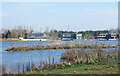
Housing at "The Lakes" Estate
Some of the large new places which have been built around some former gravel pits.
Image: © Des Blenkinsopp
Taken: 8 Mar 2022
0.20 miles
8
![A figure of eight walk from Lechlade-on-Thames [33]](https://s3.geograph.org.uk/geophotos/07/26/52/7265227_b7252e14_120x120.jpg)
A figure of eight walk from Lechlade-on-Thames [33]
Here the access road, also a public footpath, is known as Bowmoor Reach.
After leaving Lechlade, the route joins the long distance Thames and Severn Way and passes the southern edge of Bowmoor Lake. Turning north, and looping around the northern edge of the lake, the Thames and Severn Way is re-joined and followed to the banks of the River Thames and back to Lechlade. Slightly over 5 miles.
Image: © Michael Dibb
Taken: 8 Jun 2022
0.23 miles
9
![A figure of eight walk from Lechlade-on-Thames [26]](https://s3.geograph.org.uk/geophotos/07/26/52/7265211_8066e275_120x120.jpg)
A figure of eight walk from Lechlade-on-Thames [26]
This access road, also a public footpath, serves the waterfront houses on Bowmoor Lake.
After leaving Lechlade, the route joins the long distance Thames and Severn Way and passes the southern edge of Bowmoor Lake. Turning north, and looping around the northern edge of the lake, the Thames and Severn Way is re-joined and followed to the banks of the River Thames and back to Lechlade. Slightly over 5 miles.
Image: © Michael Dibb
Taken: 8 Jun 2022
0.24 miles
10
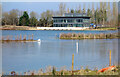
One of the Lakeside Houses
A closer look at one of the luxurious large premises which have been built along the shores of several former gravel quarries in this area.
Image: © Des Blenkinsopp
Taken: 8 Mar 2022
0.25 miles