
IMAGES TAKEN NEAR TO
West Allcourt, LECHLADE, GL7 3FA
Introduction
This page details the photographs taken nearby to West Allcourt, GL7 3FA by members of the Geograph project.
The Geograph project started in 2005 with the aim of publishing, organising and preserving representative images for every square kilometre of Great Britain, Ireland and the Isle of Man.

There are currently over 7.5m images from over14,400 individuals and you can help contribute to the project by visiting https://www.geograph.org.uk
Image Map
Images are licensed for reuse under creativecommons.org/licenses/by-sa/2.0
Notes
- Clicking on the map will re-center to the selected point.
- The higher the marker number, the further away the image location is from the centre of the postcode.
Image Listing (308 Images Found)
Images are licensed for reuse under creativecommons.org/licenses/by-sa/2.0
Image
Details
Distance
1
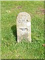
Common no more
Once very common these markers gave the distance in feet and inches to a main junction point of GPO phone cables.
Image: © Michael Dibb
Taken: 3 Apr 2019
0.02 miles
2
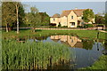
Pond, Allcourt Meadow, Lechlade
Allcourt Meadow, prior to redevelopment of the land enclosing this area, was known locally as 'Tom Warner's Field'.
Image: © Rob Noble
Taken: 25 Apr 2011
0.02 miles
4
![Allcourt Meadow [2]](https://s1.geograph.org.uk/geophotos/06/11/37/6113713_b7c981a9_120x120.jpg)
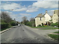
Allcourt Meadow [2]
A pond in the pleasant green space near the centre of Lechlade, surrounded by attractive houses for the over 55s.
Lechlade on Thames was once a thriving inland port handling salt, wool and cheese. The town is now a popular venue for tourism and river-based activities.
Image: © Michael Dibb
Taken: 3 Apr 2019
0.03 miles
5
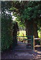
Entrance to the Seven Stiles Stroll from High Street, Lechlade on Thames
This gate is the entrance to what is called the Seven Stiles Stroll, a pleasant walk through fields and paths down to the River Thames. It can easily be incorporated into a circular walk. Most if not all of the stiles have been replaced by gates. Particularly welcome is this gate which has replaced a particularly difficult access, especially if you wished to get a dog or two through it!
Image
Image: © P L Chadwick
Taken: 24 Mar 2012
0.04 miles
6
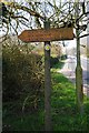
Fingerpost in High Street, Lechlade on Thames
The fingerpost points to the High Street entrance to the Seven Stiles Stroll. This walk will take you to the River Thames as well as the Thames & Severn Canal and the Roundhouse. The latter two are not currently open to the public.
Image
Image: © P L Chadwick
Taken: 24 Mar 2012
0.04 miles
7
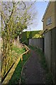
Seven Stiles Stroll near High Street, Lechlade on Thames
This section of the Seven Stiles Stroll is near the High Street. See:- Image
Image: © P L Chadwick
Taken: 24 Mar 2012
0.05 miles
8
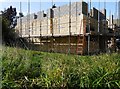
Building under construction, High Street, Lechlade on Thames, Glos
A new building under construction, presumably a house. Photographed from the public footpath running along one side.
Image: © P L Chadwick
Taken: 23 Sep 2017
0.05 miles
9
![A figure of eight walk from Lechlade-on-Thames [2]](https://s0.geograph.org.uk/geophotos/07/26/33/7263320_5f617053_120x120.jpg)
A figure of eight walk from Lechlade-on-Thames [2]
The route leaves High Street, A417, into a passage between houses.
After leaving Lechlade, the route joins the long distance Thames and Severn Way and passes the southern edge of Bowmoor Lake. Turning north, and looping around the northern edge of the lake, the Thames and Severn Way is re-joined and followed to the banks of the River Thames and back to Lechlade. Slightly over 5 miles.
Image: © Michael Dibb
Taken: 8 Jun 2022
0.05 miles
10
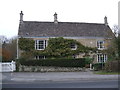
Bridge House, Downington, Lechlade
Grade II Listed http://www.britishlistedbuildings.co.uk/en-128998-bridge-house-lechlade-gloucestershire detached late 18th century Cotswold stone house with stone slate roof, consisting of a single long range of two storeys, possibly built in two stages. The upper storey has three windows: triple sashes on either side in cambered stone surrounds, and a straiqht-headed central sash. The ground floor has two similar triple sashes, and a central stone doorcase with an open moulded pediment with rosettes in the frieze, pilasters, and a decorative radial fanlight and a half-glazed door. There is a small single-storey wing to the right-hand side.
Image: © Vieve Forward
Taken: 1 Dec 2013
0.05 miles