IMAGES TAKEN NEAR TO
Hambidge Lane, LECHLADE, GL7 3ED
Introduction
This page details the photographs taken nearby to Hambidge Lane, GL7 3ED by members of the Geograph project.
The Geograph project started in 2005 with the aim of publishing, organising and preserving representative images for every square kilometre of Great Britain, Ireland and the Isle of Man.

There are currently over 7.5m images from over14,400 individuals and you can help contribute to the project by visiting https://www.geograph.org.uk
Image Map
Images are licensed for reuse under creativecommons.org/licenses/by-sa/2.0
Notes
- Clicking on the map will re-center to the selected point.
- The higher the marker number, the further away the image location is from the centre of the postcode.
Image Listing (5 Images Found)
Images are licensed for reuse under creativecommons.org/licenses/by-sa/2.0
Image
Details
Distance
1

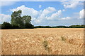
Barn at Stud Farm on the outskirts of Lechlade
Image: © Jonathan Billinger
Taken: 19 Dec 2006
0.05 miles
2
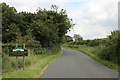
Entering Lechlade along Hambidge Lane (old Salt Way)
The sign reads "Lechlade on Thames - Historic inland port". Hambridge Lane is part of the old Salt Way, a medieval trade route where salt was brought from Droitwich in Cheshire to Lechlade by pack horse trains and transferred to barges for shipping down the Thames to London.
Image: © Rob Noble
Taken: 8 Jul 2012
0.06 miles
4
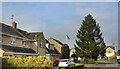
Ukrainian Flag, Lechlade
Suburban housing on the north side of Lechlade.
A point in time detail is the Ukrainian flag flying outside one of the houses.
This is a flag now being seen in increasing numbers all over the country as people express support for that unfortunate nation in the face of Russian war crimes.
Image: © Des Blenkinsopp
Taken: 8 Mar 2022
0.14 miles
5
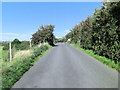
Hambidge Lane crosses bridge over dismantled railway
In 1873 the East Gloucestershire Railway Company built 14 miles (23 km) of line from the Witney Railway at Witney to Fairford. It was closed to goods traffic in 1970. See: http://en.wikipedia.org/wiki/Oxford,_Witney_and_Fairford_Railway
Image: © Stuart Logan
Taken: 13 Sep 2012
0.18 miles