IMAGES TAKEN NEAR TO
Market Square, LECHLADE, GL7 3AB
Introduction
This page details the photographs taken nearby to Market Square, GL7 3AB by members of the Geograph project.
The Geograph project started in 2005 with the aim of publishing, organising and preserving representative images for every square kilometre of Great Britain, Ireland and the Isle of Man.

There are currently over 7.5m images from over14,400 individuals and you can help contribute to the project by visiting https://www.geograph.org.uk
Image Map
Images are licensed for reuse under creativecommons.org/licenses/by-sa/2.0
Notes
- Clicking on the map will re-center to the selected point.
- The higher the marker number, the further away the image location is from the centre of the postcode.
Image Listing (448 Images Found)
Images are licensed for reuse under creativecommons.org/licenses/by-sa/2.0
Image
Details
Distance
1
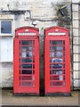
K6 Telephone boxes
Two K6 telephone boxes, designed in 1935 by Sir Giles Gilbert Scott. Listed, grade II, with details at: https://historicengland.org.uk/listing/the-list/list-entry/1089387
Image: © Michael Dibb
Taken: 3 Apr 2019
0.00 miles
2
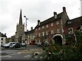
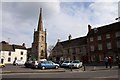
Lechlade - Market Place
St Lawrence, the parish church, stands beside the Community Library / Local Tourist Office and the New Inn Hotel, a former coaching inn.
www.lechladeonthames.co.uk
Image: © Colin Smith
Taken: 5 Aug 2023
0.00 miles
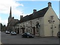
4
Red House Restaurant, Lechlade
Overlooking the market Place this red-brick building, formerly the New Inn dates from around 1750.
Image: © Philip Halling
Taken: 21 May 2011
0.01 miles
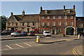
5
New Inn Hotel
Old coaching inn by Lechlade's Market Square. The parish church spire is in the background.
Image: © Colin Smith
Taken: 27 Dec 2007
0.01 miles
6
![Lechlade houses [25]](https://s0.geograph.org.uk/geophotos/06/11/07/6110756_a3261ce4_120x120.jpg)
Lechlade houses [25]
The Cottage (left) is late 18th century and is listed, grade II, with details at: https://historicengland.org.uk/listing/the-list/list-entry/1341288
Church Cottage (right) is mid 18th century and used for church business. Listed, grade II, with details at: https://historicengland.org.uk/listing/the-list/list-entry/1155979
Lechlade on Thames was once a thriving inland port handling salt, wool and cheese. The town is now a popular venue for tourism and river-based activities.
Image: © Michael Dibb
Taken: 3 Apr 2019
0.01 miles
8

Shelley's Walk, Lechlade-on-Thames, Glos
This public footpath named Shelley's Walk runs through the cemetery and alongside the Parish Church and leads to the Market Square and High Street. On the wall on the right is a plaque, see:- Image
Image: © P L Chadwick
Taken: 23 Jul 2016
0.01 miles
9
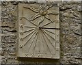
Lechlade: Sundial on building next to St. Lawrence's Church
Image: © Michael Garlick
Taken: 23 Jun 2017
0.01 miles
10
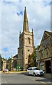
St Lawrence, Lechlade
Seen from the Market Place, the church was almost entirely rebuilt in the late 15th century - clear evidence of the wealth of the town at the time.
Image: © Philip Pankhurst
Taken: 13 Jul 2019
0.01 miles