IMAGES TAKEN NEAR TO
The Waterloo, CIRENCESTER, GL7 2QX
Introduction
This page details the photographs taken nearby to The Waterloo, GL7 2QX by members of the Geograph project.
The Geograph project started in 2005 with the aim of publishing, organising and preserving representative images for every square kilometre of Great Britain, Ireland and the Isle of Man.

There are currently over 7.5m images from over14,400 individuals and you can help contribute to the project by visiting https://www.geograph.org.uk
Image Map
Images are licensed for reuse under creativecommons.org/licenses/by-sa/2.0
Notes
- Clicking on the map will re-center to the selected point.
- The higher the marker number, the further away the image location is from the centre of the postcode.
Image Listing (699 Images Found)
Images are licensed for reuse under creativecommons.org/licenses/by-sa/2.0
Image
Details
Distance
1
![Cirencester parks and spaces [8]](https://s0.geograph.org.uk/geophotos/06/37/54/6375400_e9823ee2_120x120.jpg)
Cirencester parks and spaces [8]
A footbridge over a branch of the River Churn in Abbey Grounds.
Cirencester, the largest town in the Cotswolds, is a market town some 15 miles south east of Gloucester and some 13 miles north west of Swindon. The town lies on the River Churn, a tributary of the River Thames and is the hub of a network of roads. It is the home of the Royal Agricultural University, founded in 1840. An important Roman settlement known as Corinium, the town, with 240 acres enclosed by walls was second only to London in size.
Image: © Michael Dibb
Taken: 11 Dec 2019
0.04 miles
2

East across the churchyard, St John's Church, Cirencester
Viewed from the roof of the church tower, beyond the churchyard and its graves are modern flats in The Waterloo.
Image: © Brian Robert Marshall
Taken: 28 Jun 2014
0.05 miles
3
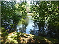
The River Churn, Cirencester
This is where the river flows into a lake in The Abbey Grounds.
Image: © pam fray
Taken: 15 Sep 2016
0.06 miles
4
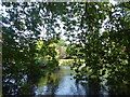
The River Churn, Cirencester
This is where the river flows into a lake in The Abbey Grounds.
Image: © pam fray
Taken: 15 Sep 2016
0.06 miles
5
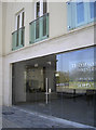
Glass houses
Some modern apartments and retail units along The Waterloo feature plenty of glass - including balconies with French windows.
Image: © Neil Owen
Taken: 14 Apr 2015
0.07 miles

7
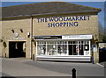
The Woolmarket
As seen from The Waterloo, the small shopping arcade occupies an area just off the main road through the town.
Image: © Neil Owen
Taken: 14 Apr 2015
0.07 miles
8
![Cirencester parks and spaces [13]](https://s3.geograph.org.uk/geophotos/06/84/65/6846571_f86d8aa4_120x120.jpg)
Cirencester parks and spaces [13]
The lake in the Abbey Grounds was originally the trout lake for the abbey. The grounds are the site of St Mary's Abbey, consecrated in 1176. After the dissolution in 1539 the Abbey was completely demolished.
Cirencester, the largest town in the Cotswolds, is a market town some 15 miles south east of Gloucester and some 13 miles north west of Swindon. The town lies on the River Churn, a tributary of the River Thames and is the hub of a network of roads. It is the home of the Royal Agricultural University, founded in 1840. An important Roman settlement known as Corinium, the town, with 240 acres enclosed by walls was second only to London in size.
Image: © Michael Dibb
Taken: 12 May 2021
0.07 miles
9
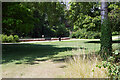
Abbey Grounds, Cirencester
This is a peaceful corner of the park with a bench overlooking the lake and some welcome shade on a warm sunny day.
Image: © Stephen McKay
Taken: 29 Jul 2022
0.07 miles
10
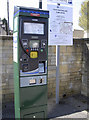
The ever-changing face of technology
A car park meter. Not just any old meter. Not just an electrically powered meter that prints out a ticket. It is the latest word in money transfer systems - the machine takes cash and plastic methods (hence the keypad). It won't be long before they give you a map of where you want to go and send you a text message when you're late...
Image: © Neil Owen
Taken: 14 Apr 2015
0.08 miles