IMAGES TAKEN NEAR TO
The Waterloo, CIRENCESTER, GL7 2PZ
Introduction
This page details the photographs taken nearby to The Waterloo, GL7 2PZ by members of the Geograph project.
The Geograph project started in 2005 with the aim of publishing, organising and preserving representative images for every square kilometre of Great Britain, Ireland and the Isle of Man.

There are currently over 7.5m images from over14,400 individuals and you can help contribute to the project by visiting https://www.geograph.org.uk
Image Map
Images are licensed for reuse under creativecommons.org/licenses/by-sa/2.0
Notes
- Clicking on the map will re-center to the selected point.
- The higher the marker number, the further away the image location is from the centre of the postcode.
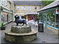
Image Listing (890 Images Found)
Images are licensed for reuse under creativecommons.org/licenses/by-sa/2.0
Image
Details
Distance
2
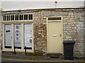
The Smithy
Almost completely overshadowed by the modern signage is a little clue as to this building's past.
Image: © Neil Owen
Taken: 18 Aug 2014
0.03 miles
3
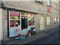
Pretty frocks and bric a brac
Little shop on The Waterloo.
Image: © Peter Barr
Taken: 4 May 2013
0.03 miles
4
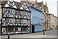
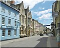
Buildings on Market Place
This frontage has been in place for quite a long time.
Image: © Bill Boaden
Taken: 26 May 2018
0.04 miles
5
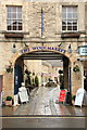
Entrance to The Woolmarket
Viewed from Dyer Street.
Image: © Rob Noble
Taken: 16 Nov 2012
0.04 miles
6
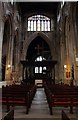
The nave in St John's Church in Cirencester
Image: © Steve Daniels
Taken: 31 Jul 2009
0.05 miles
7
![Cirencester buildings [9]](https://s1.geograph.org.uk/geophotos/06/10/19/6101933_1061a035_120x120.jpg)
Cirencester buildings [9]
The Fleece hotel occupies three buildings - this is the one on the right. Stuccoed with 3 storeys and an attic, this was built in the mid 18th century. The other buildings are seen at Image (centre) and Image (left). Listed, grade II, with details at: https://historicengland.org.uk/listing/the-list/list-entry/1187504
Cirencester, the largest town in the Cotswolds, is a market town some 15 miles south east of Gloucester and some 13 miles north west of Swindon. The town lies on the River Churn, a tributary of the River Thames and is the hub of a network of roads. It is the home of the Royal Agricultural University, founded in 1840. An important Roman settlement known as Corinium, the town, with 240 acres enclosed by walls was second only to London in size.
Image: © Michael Dibb
Taken: 20 Mar 2019
0.05 miles
8
Cirencester, Bingham Hall
Venue on King Street, formerly a library. The building dates from 1904: https://www.binghamhall.co.uk/
Image: © Mike Faherty
Taken: 5 Jul 2021
0.05 miles
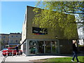
9
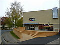
Cirencester Public Library
This modern building was thoughtfully sited on a back street near the town centre.
Image: © Jonathan Billinger
Taken: 5 Nov 2008
0.05 miles
10
The Woolmarket 2
Wool - the source of Cirencester's wealth in the Middle Ages.
Image: © Jonathan Billinger
Taken: 5 Nov 2008
0.05 miles