IMAGES TAKEN NEAR TO
Barnway, CIRENCESTER, GL7 2NA
Introduction
This page details the photographs taken nearby to Barnway, GL7 2NA by members of the Geograph project.
The Geograph project started in 2005 with the aim of publishing, organising and preserving representative images for every square kilometre of Great Britain, Ireland and the Isle of Man.

There are currently over 7.5m images from over14,400 individuals and you can help contribute to the project by visiting https://www.geograph.org.uk
Image Map
Images are licensed for reuse under creativecommons.org/licenses/by-sa/2.0
Notes
- Clicking on the map will re-center to the selected point.
- The higher the marker number, the further away the image location is from the centre of the postcode.
Image Listing (12 Images Found)
Images are licensed for reuse under creativecommons.org/licenses/by-sa/2.0
Image
Details
Distance
1
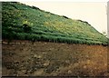
![A walk through Cirencester Park and Stratton [28]](https://s2.geograph.org.uk/geophotos/06/84/55/6845586_41461f4b_120x120.jpg)
A walk through Cirencester Park and Stratton [28]
From Barn Way this public footpath runs to School Hill.
The village of Stratton was once a separate parish. It is now part of Cirencester, the centre of which lies about one mile south.
Cirencester, the largest town in the Cotswolds, is a market town some 15 miles south east of Gloucester and some 13 miles north west of Swindon. The town lies on the River Churn, a tributary of the River Thames and is the hub of a network of roads. It is the home of the Royal Agricultural University, founded in 1840. An important Roman settlement known as Corinium, the town, with 240 acres enclosed by walls was second only to London in size.
Image: © Michael Dibb
Taken: 12 May 2021
0.11 miles
2
![A walk through Cirencester Park and Stratton [27]](https://s1.geograph.org.uk/geophotos/06/84/55/6845585_123469cd_120x120.jpg)
A walk through Cirencester Park and Stratton [27]
The track becomes enclosed and is now part of Barn Way, Stratton
The village of Stratton was once a separate parish. It is now part of Cirencester, the centre of which lies about one mile south.
Cirencester, the largest town in the Cotswolds, is a market town some 15 miles south east of Gloucester and some 13 miles north west of Swindon. The town lies on the River Churn, a tributary of the River Thames and is the hub of a network of roads. It is the home of the Royal Agricultural University, founded in 1840. An important Roman settlement known as Corinium, the town, with 240 acres enclosed by walls was second only to London in size.
Image: © Michael Dibb
Taken: 12 May 2021
0.13 miles
3
![A walk through Cirencester Park and Stratton [29]](https://s3.geograph.org.uk/geophotos/06/84/55/6845587_ef6bd51f_120x120.jpg)
A walk through Cirencester Park and Stratton [29]
Seen from Barn Way is this glimpse of Stratton House Hotel. Built in the early 19th century with later 19th century and 20th century alterations and extensions. Constructed of coursed, squared limestone and coursed rubble with some ashlar under an artificial slate roof. Some original internal features remain. Listed, grade II, with details at: https://historicengland.org.uk/listing/the-list/list-entry/1187469
The village of Stratton was once a separate parish. It is now part of Cirencester, the centre of which lies about one mile south.
Cirencester, the largest town in the Cotswolds, is a market town some 15 miles south east of Gloucester and some 13 miles north west of Swindon. The town lies on the River Churn, a tributary of the River Thames and is the hub of a network of roads. It is the home of the Royal Agricultural University, founded in 1840. An important Roman settlement known as Corinium, the town, with 240 acres enclosed by walls was second only to London in size.
Image: © Michael Dibb
Taken: 12 May 2021
0.13 miles
4
![A walk through Cirencester Park and Stratton [30]](https://s0.geograph.org.uk/geophotos/06/84/55/6845588_edcc0387_120x120.jpg)
A walk through Cirencester Park and Stratton [30]
From Barn Way, Donside runs south and becomes a public footpath leading to Gloucester Road.
The village of Stratton was once a separate parish. It is now part of Cirencester, the centre of which lies about one mile south.
Cirencester, the largest town in the Cotswolds, is a market town some 15 miles south east of Gloucester and some 13 miles north west of Swindon. The town lies on the River Churn, a tributary of the River Thames and is the hub of a network of roads. It is the home of the Royal Agricultural University, founded in 1840. An important Roman settlement known as Corinium, the town, with 240 acres enclosed by walls was second only to London in size.
Image: © Michael Dibb
Taken: 12 May 2021
0.13 miles
6
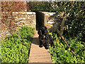
Stone Stile, Stratton
A suburb of Cirencester. On Gloucestershire footpath ZCC6 looking NW, the view out is Image The dog is called Brec.
Image: © Jayne Tovey
Taken: 14 Apr 2021
0.17 miles
7
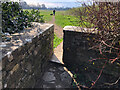
Stone Stile, Stratton
A suburb of Cirencester. On Gloucestershire footpath ZCC6 looking SE, the view looking back is Image The dog is called Brec.
Image: © Jayne Tovey
Taken: 14 Apr 2021
0.17 miles
8
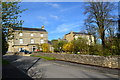
Georgian houses on Gloucester Road, Stratton
Image: © Peter Barr
Taken: 3 May 2013
0.20 miles
9
Old Milestone Gloucester Road, Stratton
Metal plate attached to stone post by the UC road (was A417), in parish of CIRENCESTER (COTSWOLD District), by No. 27 Gloucester Road, Stratton, by the road. Erected by the Cirencester to Birdlip turnpike trust in the 19th century.
Inscription reads: CIRENᴿ / 1 / Gloster / 16
Grade II Listed see https://historicengland.org.uk/listing/the-list/list-entry/1187414
Milestone Society National ID: GL_LG91
Image: © Mr Red
Taken: 11 Oct 2021
0.20 miles
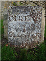
10
Old Milestone by the former A417, Gloucester Road, Stratton
Metal plate attached to stone post by the UC road (was A417), in parish of CIRENCESTER (COTSWOLD District), by No. 27 Gloucester Road, Stratton, by the road. Erected by the Cirencester to Birdlip turnpike trust in the 19th century.
For updated photo see: Image
Inscription reads:-
CIREN:R
1
GLOSTER
16
Grade II listed.
List Entry Number: 1187414 https://historicengland.org.uk/listing/the-list/list-entry/1187414
Milestone Society National ID: GL_LG91.
Image: © JM Weightmann
Taken: 1 Dec 1999
0.20 miles