IMAGES TAKEN NEAR TO
Baunton Lane, CIRENCESTER, GL7 2LN
Introduction
This page details the photographs taken nearby to Baunton Lane, GL7 2LN by members of the Geograph project.
The Geograph project started in 2005 with the aim of publishing, organising and preserving representative images for every square kilometre of Great Britain, Ireland and the Isle of Man.

There are currently over 7.5m images from over14,400 individuals and you can help contribute to the project by visiting https://www.geograph.org.uk
Image Map
Images are licensed for reuse under creativecommons.org/licenses/by-sa/2.0
Notes
- Clicking on the map will re-center to the selected point.
- The higher the marker number, the further away the image location is from the centre of the postcode.
Image Listing (7 Images Found)
Images are licensed for reuse under creativecommons.org/licenses/by-sa/2.0
Image
Details
Distance
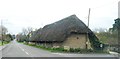
5
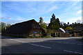
Old Barn, School Hill, Stratton
Long thatched barn, on Gloucester Road.
Image: © Peter Barr
Taken: 3 May 2013
0.20 miles
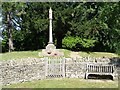
7
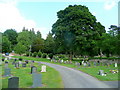
Stratton cemetery
Half the cemetery is just within the south-west corner of the gridsquare.
Image: © Jonathan Billinger
Taken: 2 Jun 2010
0.23 miles