IMAGES TAKEN NEAR TO
Cheltenham Road, CIRENCESTER, GL7 2JD
Introduction
This page details the photographs taken nearby to Cheltenham Road, GL7 2JD by members of the Geograph project.
The Geograph project started in 2005 with the aim of publishing, organising and preserving representative images for every square kilometre of Great Britain, Ireland and the Isle of Man.

There are currently over 7.5m images from over14,400 individuals and you can help contribute to the project by visiting https://www.geograph.org.uk
Image Map
Images are licensed for reuse under creativecommons.org/licenses/by-sa/2.0
Notes
- Clicking on the map will re-center to the selected point.
- The higher the marker number, the further away the image location is from the centre of the postcode.
Image Listing (15 Images Found)
Images are licensed for reuse under creativecommons.org/licenses/by-sa/2.0
Image
Details
Distance
1
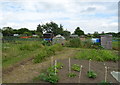
Allotments, Stratton
Off Cheltenham Road (A435).
Image: © JThomas
Taken: 11 Jul 2019
0.07 miles
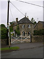
2
Old Toll House, Stratton, Cirencester
The Pike House for the Cirencester Turnpike Trust &/or the Cirencester to Birdlip Turnpike Trust, located at 91 Cheltenham Road since the 1880s. Formally situated at the junction with the Gloucester Road, Ermin Way (SP 01685 03087). An alternative view is Image
Milestone Society National ID: GL.STR (TBC)
Image: © Mr Red
Taken: 19 Apr 2022
0.08 miles
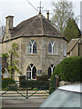
3
Old Toll House by Cheltenham Road, Stratton
Toll House in the parish of Cirencester (Cotswold District), The Pike House, No. 91, Cheltenham Road (A435), GL7.
Grade II listed.
List Entry Number: 1187439 https://historicengland.org.uk/listing/the-list/list-entry/1187439
Surveyed
Milestone Society National ID: GL.CIR
Image: © Alan Rosevear
Taken: 21 May 2005
0.08 miles
4
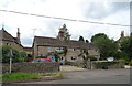
Cottages on Cheltenham Road (A435), Stratton
Image: © JThomas
Taken: 11 Jul 2019
0.09 miles
5
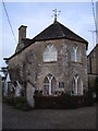
Former toll house, 91 Cheltenham Road, Stratton
Early 19th century Grade II Listed former toll house. This building originally stood on the Gloucester Road adjacent to Stratton Firs and probably pre-dates the opening of the Cheltenham turnpike in 1827. The materials were sold in 1879 when the turnpike system was abandoned and re-erected here in the 1880s. http://www.britishlistedbuildings.co.uk/en-365202-91-cheltenham-road-cirencester-glouceste
Image: © Vieve Forward
Taken: 25 Nov 2012
0.09 miles
6
Bus stop and shelter on Cheltenham Road (A435), Stratton
Image: © JThomas
Taken: 11 Jul 2019
0.12 miles
7
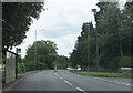
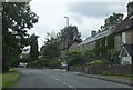
Cheltenham Road near Roberts Close
Looking southwards.
Image: © Ruth Riddle
Taken: 21 Jul 2012
0.14 miles
8
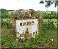
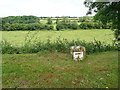
Milestone on Cheltenham Road (A435), Stratton
Inscription reads: CIREN.R 1 / CHELT.M 14.
See Image] for context.
Image: © JThomas
Taken: 11 Jul 2019
0.19 miles
9
Cheltenham Road in Stratton
Cheltenham Road is at the eastern edge of Stratton.
Image: © Ruth Riddle
Taken: 21 Jul 2012
0.19 miles
10
Milestone on Cheltenham Road (A435), Stratton
See Image] for close up.
Image: © JThomas
Taken: 11 Jul 2019
0.19 miles