IMAGES TAKEN NEAR TO
Hereward Road, CIRENCESTER, GL7 2EH
Introduction
This page details the photographs taken nearby to Hereward Road, GL7 2EH by members of the Geograph project.
The Geograph project started in 2005 with the aim of publishing, organising and preserving representative images for every square kilometre of Great Britain, Ireland and the Isle of Man.

There are currently over 7.5m images from over14,400 individuals and you can help contribute to the project by visiting https://www.geograph.org.uk
Image Map
Images are licensed for reuse under creativecommons.org/licenses/by-sa/2.0
Notes
- Clicking on the map will re-center to the selected point.
- The higher the marker number, the further away the image location is from the centre of the postcode.
Image Listing (612 Images Found)
Images are licensed for reuse under creativecommons.org/licenses/by-sa/2.0
Image
Details
Distance
1
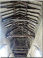
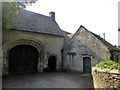
Roof of St. John's Hospital, Spitalgate Lane, Cirencester
Remains of the Hospital and Chantry of St. John the Evangelist, founded in the 12th century by Henry II.
Image: © pam fray
Taken: 15 Sep 2016
0.04 miles
2
St. John's Hospital, Cirencester
Remains of the Hospital and Chantry of St. John the Evangelist, founded in the 12th century by Henry II. In Spitalgate Lane.
Image: © pam fray
Taken: 15 Sep 2016
0.04 miles
3
![Cirencester parks and spaces [7]](https://s0.geograph.org.uk/geophotos/06/37/47/6374784_6b120842_120x120.jpg)
Cirencester parks and spaces [7]
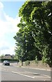
Seen from Spitalgate Lane is the River Churn, looking upstream, as it flows along the edge of the small parkland seen at Image
Cirencester, the largest town in the Cotswolds, is a market town some 15 miles south east of Gloucester and some 13 miles north west of Swindon. The town lies on the River Churn, a tributary of the River Thames and is the hub of a network of roads. It is the home of the Royal Agricultural University, founded in 1840. An important Roman settlement known as Corinium, the town, with 240 acres enclosed by walls was second only to London in size.
Image: © Michael Dibb
Taken: 24 Sep 2019
0.05 miles
4
![Cirencester buildings [31]](https://s2.geograph.org.uk/geophotos/06/37/47/6374778_bd1dc1ac_120x120.jpg)
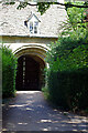
Cirencester buildings [31]
The gatehouse, Spital Gate, is all that remains of Cirencester Abbey. The gatehouse is 12th century, the attached cottage is thought to be 17th century. Listed, grade I, with details at: https://historicengland.org.uk/listing/the-list/list-entry/1187492
Cirencester, the largest town in the Cotswolds, is a market town some 15 miles south east of Gloucester and some 13 miles north west of Swindon. The town lies on the River Churn, a tributary of the River Thames and is the hub of a network of roads. It is the home of the Royal Agricultural University, founded in 1840. An important Roman settlement known as Corinium, the town, with 240 acres enclosed by walls was second only to London in size.
Image: © Michael Dibb
Taken: 24 Sep 2019
0.05 miles
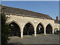
5
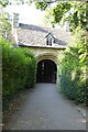
Spital Gate
In Medieval times Cirencester had a large and important Augustinian abbey. In common with all monastic establishments in England, it was dissolved by Henry VIII in the 1530s. The building, which from all accounts was especially grand, was razed to the ground and almost all physical traces have now disappeared. However, this 12th century gatehouse survived and is now grade I listed.
Image: © Stephen McKay
Taken: 29 Jul 2022
0.05 miles
6
Gatehouse to the former Abbey
Spital Gate, a 12th century former Norman gatehouse to Cirencester Abbey. The gatehouse is Grade I listed, see: https://historicengland.org.uk/listing/the-list/list-entry/1091221?section=official-list-entry
Image: © Philip Halling
Taken: 12 Aug 2022
0.05 miles
7
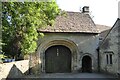
Gatehouse to the former Abbey
Spital Gate, a 12th century former Norman gatehouse to Cirencester Abbey. The gatehouse is Grade I listed, see: https://historicengland.org.uk/listing/the-list/list-entry/1091221?section=official-list-entry
Image: © Philip Halling
Taken: 12 Aug 2022
0.05 miles
8
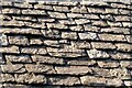
Cotswold stone roof slates
Cotswold stone roof slates on the former gatehouse to Cirencester Abbey.
Image: © Philip Halling
Taken: 12 Aug 2022
0.05 miles
9
Norman arch, Grove Lane, Cirencester
Built in the 12th century, it is the only remaining building of the Augustinian Abbey which stood here.
Image: © pam fray
Taken: 15 Sep 2016
0.05 miles