
IMAGES TAKEN NEAR TO
Gloucester Street, CIRENCESTER, GL7 2DH
Introduction
This page details the photographs taken nearby to Gloucester Street, GL7 2DH by members of the Geograph project.
The Geograph project started in 2005 with the aim of publishing, organising and preserving representative images for every square kilometre of Great Britain, Ireland and the Isle of Man.

There are currently over 7.5m images from over14,400 individuals and you can help contribute to the project by visiting https://www.geograph.org.uk
Image Map
Images are licensed for reuse under creativecommons.org/licenses/by-sa/2.0
Notes
- Clicking on the map will re-center to the selected point.
- The higher the marker number, the further away the image location is from the centre of the postcode.
Image Listing (389 Images Found)
Images are licensed for reuse under creativecommons.org/licenses/by-sa/2.0
Image
Details
Distance
1
![Cirencester houses [51]](https://s3.geograph.org.uk/geophotos/06/85/79/6857975_dbb9f7e7_120x120.jpg)
Cirencester houses [51]
Number 60 Gloucester Street, (nearest the camera) is late 17th or early 18th century, gable to the street. Numbers 56 and 58 Gloucester Street are early or mid 18th century. The three houses are built of coursed rubble stone under a continuous stone slate roof. There is a continuous two-storey rear extension to the rear of all three houses. Listed, grade II, with details at: https://historicengland.org.uk/listing/the-list/list-entry/1187475 for number 60 and at: https://historicengland.org.uk/listing/the-list/list-entry/1298676 for numbers 56 and 58.
Cirencester, the largest town in the Cotswolds, is a market town some 15 miles south east of Gloucester and some 13 miles north west of Swindon. The town lies on the River Churn, a tributary of the River Thames and is the hub of a network of roads. It is the home of the Royal Agricultural University, founded in 1840. An important Roman settlement known as Corinium, the town, with 240 acres enclosed by walls was second only to London in size.
Image: © Michael Dibb
Taken: 12 May 2021
0.00 miles
2
![Cirencester houses [50]](https://s1.geograph.org.uk/geophotos/06/85/79/6857965_ab00ffe8_120x120.jpg)
Cirencester houses [50]
The three houses at numbers 50, 52 and 54 Gloucester Street were built in 1902 for the Bathurst Estate. Constructed of coursed, squared limestone to the front with brick to the rear and to the rear extensions, under a concrete tile roof. Listed, for group value, grade II, with details at: https://historicengland.org.uk/listing/the-list/list-entry/1206027
Cirencester, the largest town in the Cotswolds, is a market town some 15 miles south east of Gloucester and some 13 miles north west of Swindon. The town lies on the River Churn, a tributary of the River Thames and is the hub of a network of roads. It is the home of the Royal Agricultural University, founded in 1840. An important Roman settlement known as Corinium, the town, with 240 acres enclosed by walls was second only to London in size.
Image: © Michael Dibb
Taken: 12 May 2021
0.00 miles
3
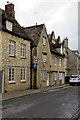
20 Zone sign, Gloucester Street, Cirencester
20 mph speed limit on the approach to a primary school.
Image: © Jaggery
Taken: 10 Feb 2016
0.01 miles
4
![Cirencester houses [52]](https://s2.geograph.org.uk/geophotos/06/85/79/6857978_f425de40_120x120.jpg)
Cirencester houses [52]
Number 62 Gloucester Street is early/mid 18th century. Built in coursed rubble stone under a stone slate roof. The large hipped full dormer window would appear to be a former hoist opening. Listed, grade II, with details at: https://historicengland.org.uk/listing/the-list/list-entry/1187476
Cirencester, the largest town in the Cotswolds, is a market town some 15 miles south east of Gloucester and some 13 miles north west of Swindon. The town lies on the River Churn, a tributary of the River Thames and is the hub of a network of roads. It is the home of the Royal Agricultural University, founded in 1840. An important Roman settlement known as Corinium, the town, with 240 acres enclosed by walls was second only to London in size.
Image: © Michael Dibb
Taken: 12 May 2021
0.01 miles
5
![Cirencester houses [48]](https://s3.geograph.org.uk/geophotos/06/85/79/6857951_2d9d43f1_120x120.jpg)
Cirencester houses [48]
Number 40 Gloucester Street is early or mid 17th century with 20th century alterations. Built of coursed rubble stone under a concrete tile roof. The front has three 17th century two-light, hollow-chamfered, stone-mullion windows. Listed, grade II, with details at: https://historicengland.org.uk/listing/the-list/list-entry/1206019
Cirencester, the largest town in the Cotswolds, is a market town some 15 miles south east of Gloucester and some 13 miles north west of Swindon. The town lies on the River Churn, a tributary of the River Thames and is the hub of a network of roads. It is the home of the Royal Agricultural University, founded in 1840. An important Roman settlement known as Corinium, the town, with 240 acres enclosed by walls was second only to London in size.
Image: © Michael Dibb
Taken: 12 May 2021
0.01 miles
6
![Cirencester houses [49]](https://s2.geograph.org.uk/geophotos/06/85/79/6857958_154e862e_120x120.jpg)
Cirencester houses [49]
The house and shop at number 48 Gloucester Street is now a number of holiday apartments. Built in the early 19th century of coursed, squared limestone with ashlar dressings under a slate roof.
Cirencester, the largest town in the Cotswolds, is a market town some 15 miles south east of Gloucester and some 13 miles north west of Swindon. The town lies on the River Churn, a tributary of the River Thames and is the hub of a network of roads. It is the home of the Royal Agricultural University, founded in 1840. An important Roman settlement known as Corinium, the town, with 240 acres enclosed by walls was second only to London in size.
Image: © Michael Dibb
Taken: 12 May 2021
0.01 miles
7
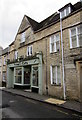
Prime Cuts, Gloucester Street, Cirencester
The hair salon at 65 Gloucester Street is in a much altered
late 17th century building which was Grade II listed in 1971.
The word INN on the doorstep is a relic of the building's former use.
Image: © Jaggery
Taken: 10 Feb 2016
0.01 miles
8
![Cirencester houses [53]](https://s2.geograph.org.uk/geophotos/06/85/79/6857990_678cf1ca_120x120.jpg)
Cirencester houses [53]
Number 66 Gloucester Street is an 18th century cottage on a double pile plan with two gables to the courtyard. Built of coursed rubble stone under a stone slate roof. The original door under the timber lintel has been blocked and the entrance is now in the left return. Listed, grade II, with details at: https://historicengland.org.uk/listing/the-list/list-entry/1187477
Cirencester, the largest town in the Cotswolds, is a market town some 15 miles south east of Gloucester and some 13 miles north west of Swindon. The town lies on the River Churn, a tributary of the River Thames and is the hub of a network of roads. It is the home of the Royal Agricultural University, founded in 1840. An important Roman settlement known as Corinium, the town, with 240 acres enclosed by walls was second only to London in size.
Image: © Michael Dibb
Taken: 12 May 2021
0.01 miles
9
![Cirencester buildings [58]](https://s1.geograph.org.uk/geophotos/06/85/79/6857985_4d752442_120x120.jpg)
Cirencester buildings [58]
The former house at number 65 Gloucester Street is now a shop with a flat above. Built in the late 17th century with later alterations. Constructed of coursed, squared limestone under a concrete tile roof with a gable to the street. The timber shop front is late 19th century. The door to the left leads to a through passage. Listed, grade II, with details at: https://historicengland.org.uk/listing/the-list/list-entry/1298677
Cirencester, the largest town in the Cotswolds, is a market town some 15 miles south east of Gloucester and some 13 miles north west of Swindon. The town lies on the River Churn, a tributary of the River Thames and is the hub of a network of roads. It is the home of the Royal Agricultural University, founded in 1840. An important Roman settlement known as Corinium, the town, with 240 acres enclosed by walls was second only to London in size.
Image: © Michael Dibb
Taken: 12 May 2021
0.02 miles
10
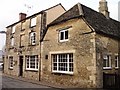
The Nelson Inn Gloucester Street Cirencester
The Nelson Inn Gloucester Street Cirencester
Historical information links
http://pubshistory.com/Gloucestershire/Cirencester/index.shtml
http://www.gloucestershirepubs.co.uk/FeatureFiller/index.php
Image: © Paul Best
Taken: 23 Mar 2013
0.02 miles