IMAGES TAKEN NEAR TO
CIRENCESTER, GL7 2BU
Introduction
This page details the photographs taken nearby to GL7 2BU by members of the Geograph project.
The Geograph project started in 2005 with the aim of publishing, organising and preserving representative images for every square kilometre of Great Britain, Ireland and the Isle of Man.

There are currently over 7.5m images from over14,400 individuals and you can help contribute to the project by visiting https://www.geograph.org.uk
Image Map
Images are licensed for reuse under creativecommons.org/licenses/by-sa/2.0
Notes
- Clicking on the map will re-center to the selected point.
- The higher the marker number, the further away the image location is from the centre of the postcode.
Image Listing (980 Images Found)
Images are licensed for reuse under creativecommons.org/licenses/by-sa/2.0
Image
Details
Distance
1
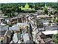
West from St John's Church tower roof, Cirencester (1)
In the background is Cirencester Park and its associated big house, normally unseen behind its high yew hedge Image The roadway leading away from the viewpoint is Black Jack Street.
Image: © Brian Robert Marshall
Taken: 28 Jun 2014
0.01 miles
2
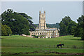
Cirencester House, Cirencester Park, Cirencester
Although the big house stands unusually close to the town centre it hides itself behind a giant yew hedge. The west front is largely the work of William Townesend, c1715. Grade II* listed.
Beyond it is Image
Image: © Stephen Richards
Taken: 17 Aug 2015
0.01 miles
3
![A walk through Cirencester Park and Stratton [4]](https://s1.geograph.org.uk/geophotos/06/84/41/6844117_9832f5c7_120x120.jpg)
A walk through Cirencester Park and Stratton [4]
Seen from Windsor Walk is Cirencester Park Mansion with the tower of the church of St John behind. The house and attached offices were built circa 1714-1718 and they probably incorporate parts of a late 16th century house. There were alterations and additions in 1830. The house has ashlar to the east front and a rendered west front. The attached offices are in coursed limestone rubble. The roofs are of Welsh slate. There are some fine original internal fittings. Listed, grade II*, with details at: https://historicengland.org.uk/listing/the-list/list-entry/1280239
Cirencester Park is a private estate of some 2,500 acres consisting of extensive woodland, with park and pleasure grounds. The park was developed from circa 1714 by the first Earl Bathurst. The park is on the Register of Historic Parks and Gardens, grade I, and there are details at: https://historicengland.org.uk/listing/the-list/list-entry/1000432
Image: © Michael Dibb
Taken: 12 May 2021
0.01 miles
4
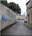
No Public Access notice facing Park Street, Cirencester
Alongside a road from Park Street into the Bathurst Estate,
the notice on the wall shows THE PUBLIC ARE NOT PERMITTED IN THIS AREA.
Image: © Jaggery
Taken: 10 Feb 2016
0.02 miles
5
Corinium Museum, Cirencester
The Corinium Museum is in Park Street, Cirencester, and has lots of wonderful Roman mosaics.
Image: © Paul Shreeve
Taken: 3 Jul 2007
0.03 miles
6
![Cirencester buildings [76]](https://s3.geograph.org.uk/geophotos/06/86/62/6866275_5ff08d6b_120x120.jpg)
Cirencester buildings [76]
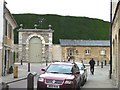
A peep into Cirencester Park Estate yard from Park Street. See also Image The stable block on the right is listed, grade II with details at: https://historicengland.org.uk/listing/the-list/list-entry/1280168
Cirencester, the largest town in the Cotswolds, is a market town some 15 miles south east of Gloucester and some 13 miles north west of Swindon. The town lies on the River Churn, a tributary of the River Thames and is the hub of a network of roads. It is the home of the Royal Agricultural University, founded in 1840. An important Roman settlement known as Corinium, the town, with 240 acres enclosed by walls was second only to London in size.
Image: © Michael Dibb
Taken: 12 May 2021
0.03 miles
7
High hedge blocks the view
A tall yew hedge at the edge of the park.
Image: © Christine Johnstone
Taken: 18 Jul 2011
0.03 miles
8
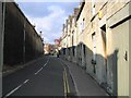
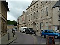
Park Street, Cirencester
The mammoth building on the left is a part of the outbuildings for the Mansion House. It is not very pretty to behold but it has always been the dominating feature of this part of the street. This is something that few people have photographed, but it has left an indelible impression on someone who once had to walk past it every day!
Image: © Tony Woodward
Taken: 28 Oct 2003
0.03 miles
9
![Cirencester features [19]](https://s2.geograph.org.uk/geophotos/06/86/62/6866278_17fbb5f9_120x120.jpg)
Cirencester features [19]
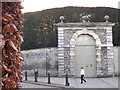
The entrance gateway to Cirencester Park. The main house is hidden behind the world's tallest Yew hedge, the clippings of which are used to produce a life-saving cancer drug called taxol. Cirencester Park is a private estate of some 2,500 acres consisting of extensive woodland, with park and pleasure grounds. The park was developed from circa 1714 by the first Earl Bathurst. The park is on the Register of Historic Parks and Gardens, grade I, and there are details at: https://historicengland.org.uk/listing/the-list/list-entry/1000432
Image: © Michael Dibb
Taken: 12 May 2021
0.03 miles
10
Cirencester Park Gateway
Imposing carriage entrance from the town leading into Cirencester Park. Note the 40 feet high yew hedge behind the stone wall.
www.cirencester.co.uk
Image: © Colin Smith
Taken: 28 Dec 2011
0.03 miles