
IMAGES TAKEN NEAR TO
Coxwell Street, CIRENCESTER, GL7 2BQ
Introduction
This page details the photographs taken nearby to Coxwell Street, GL7 2BQ by members of the Geograph project.
The Geograph project started in 2005 with the aim of publishing, organising and preserving representative images for every square kilometre of Great Britain, Ireland and the Isle of Man.

There are currently over 7.5m images from over14,400 individuals and you can help contribute to the project by visiting https://www.geograph.org.uk
Image Map
Images are licensed for reuse under creativecommons.org/licenses/by-sa/2.0
Notes
- Clicking on the map will re-center to the selected point.
- The higher the marker number, the further away the image location is from the centre of the postcode.
Image Listing (1090 Images Found)
Images are licensed for reuse under creativecommons.org/licenses/by-sa/2.0
Image
Details
Distance
1
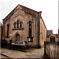
Victorian Baptist Church, Cirencester
On the south side of Coxwell Street. A blue plaque http://www.geograph.org.uk/photo/4824090 on the building records that the Baptist Church was built in 1856, possibly on the site of the house of the widow Peltrace where, from 1651, some forty Baptists met for worship. The building was Grade II listed in 1971.
Image: © Jaggery
Taken: 10 Feb 2016
0.00 miles
2
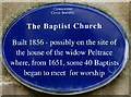
Baptist Church blue plaque, Cirencester
The Cirencester Civic Society's blue plaque is on the wall to the left of the doorway here. http://www.geograph.org.uk/photo/4824086
Image: © Jaggery
Taken: 10 Feb 2016
0.00 miles
3
![Cirencester buildings [78]](https://s2.geograph.org.uk/geophotos/07/00/09/7000986_5dd86711_120x120.jpg)
Cirencester buildings [78]
Now a dwelling, this former Baptist chapel has origins from 1651. The present building was built in 1856 and it ceased to be a chapel in 2017. Built in an Italianate style, of coursed rubble stone with an ashlar front under a tile roof. The chapel is listed, grade II, with details at: https://historicengland.org.uk/listing/the-list/list-entry/1205637 The mid 19th century cast iron gates and railings are listed separately, grade II, with details at: https://historicengland.org.uk/listing/the-list/list-entry/1298703
Cirencester, the largest town in the Cotswolds, is a market town some 15 miles south east of Gloucester and some 13 miles north west of Swindon. The town lies on the River Churn, a tributary of the River Thames and is the hub of a network of roads. It is the home of the Royal Agricultural University, founded in 1840. An important Roman settlement known as Corinium, the town, with 240 acres enclosed by walls was second only to London in size.
Image: © Michael Dibb
Taken: 15 Jun 2021
0.00 miles
4
![Cirencester buildings [79]](https://s3.geograph.org.uk/geophotos/07/00/09/7000987_b9eb75eb_120x120.jpg)
Cirencester buildings [79]
A plaque on the chapel.
Now a dwelling, this former Baptist chapel has origins from 1651. The present building was built in 1856 and it ceased to be a chapel in 2017. Built in an Italianate style, of coursed rubble stone with an ashlar front under a tile roof. The chapel is listed, grade II, with details at: https://historicengland.org.uk/listing/the-list/list-entry/1205637 The mid 19th century cast iron gates and railings are listed separately, grade II, with details at: https://historicengland.org.uk/listing/the-list/list-entry/1298703
Cirencester, the largest town in the Cotswolds, is a market town some 15 miles south east of Gloucester and some 13 miles north west of Swindon. The town lies on the River Churn, a tributary of the River Thames and is the hub of a network of roads. It is the home of the Royal Agricultural University, founded in 1840. An important Roman settlement known as Corinium, the town, with 240 acres enclosed by walls was second only to London in size.
Image: © Michael Dibb
Taken: 15 Jun 2021
0.00 miles
5
![Cirencester houses [122]](https://s3.geograph.org.uk/geophotos/07/00/09/7000979_9adfc81d_120x120.jpg)
Cirencester houses [122]
Numbers 33 and 37 Coxwell Street are either side of a through passage. Built in the early 18th century of coursed rubble stone, rendered to the right end, under an artificial slate roof. Listed, for group value, grade II, with details at: https://historicengland.org.uk/listing/the-list/list-entry/1280626
Cirencester, the largest town in the Cotswolds, is a market town some 15 miles south east of Gloucester and some 13 miles north west of Swindon. The town lies on the River Churn, a tributary of the River Thames and is the hub of a network of roads. It is the home of the Royal Agricultural University, founded in 1840. An important Roman settlement known as Corinium, the town, with 240 acres enclosed by walls was second only to London in size.
Image: © Michael Dibb
Taken: 15 Jun 2021
0.01 miles
6
![Cirencester houses [123]](https://s1.geograph.org.uk/geophotos/07/00/09/7000989_0de84d44_120x120.jpg)
Cirencester houses [123]
Built as one house, this is now three dwellings, numbers 39, 41 and 43 Cox well Street. There is a mid 17th century rear wing to the range fronting the street, which was rebuilt in the 19th century. There are other 19th century additions and alterations in the 20th century. Constructed of coursed rubble stone with ashlar dressings under roofs of stone slate and Welsh slate. Listed, grade II, with details at: https://historicengland.org.uk/listing/the-list/list-entry/1205620
Cirencester, the largest town in the Cotswolds, is a market town some 15 miles south east of Gloucester and some 13 miles north west of Swindon. The town lies on the River Churn, a tributary of the River Thames and is the hub of a network of roads. It is the home of the Royal Agricultural University, founded in 1840. An important Roman settlement known as Corinium, the town, with 240 acres enclosed by walls was second only to London in size.
Image: © Michael Dibb
Taken: 15 Jun 2021
0.01 miles
7
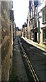
Coxwell Street, Cirencester
Coxwell Street is one of several small thoroughfares in the centre of Cirencester. This area contains a diverse mix of architectural styles.
Image: © Brian Robert Marshall
Taken: 7 Mar 2014
0.01 miles
8
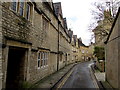
Bend in Coxwell Street, Cirencester
Viewed from the Dollar Street end looking towards the bend at the entrance to Cirencester Baptist Church. http://www.geograph.org.uk/photo/4824086 Double yellow lines on both sides indicate no parking at any time.
Image: © Jaggery
Taken: 10 Feb 2016
0.01 miles
9
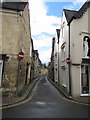
Coxwell Street, Cirencester
No entry for vehicles from Dollar Street to this narrow street where
double yellow lines on both sides indicate no parking at any time.
Image: © Jaggery
Taken: 10 Feb 2016
0.01 miles
10
![Cirencester houses [114]](https://s3.geograph.org.uk/geophotos/07/00/09/7000931_e278bbcd_120x120.jpg)
Cirencester houses [114]
Built originally in 1640 as one house, now two, numbers 10 and 10A Coxwell Street have been much altered in the 19th and 20th centuries. There is a carriage entrance between the houses. Number 10A, Image, is constructed of coursed rubble stone under a stone slate roof. Number 10, seen here, is constructed of rendered rubble stone under a Welsh slate roof. Number 10 has a large 17th century round-headed doorcase with a boarded and framed round-headed door - see Image Listed, grade II, with details at: https://historicengland.org.uk/listing/the-list/list-entry/1298700
Cirencester, the largest town in the Cotswolds, is a market town some 15 miles south east of Gloucester and some 13 miles north west of Swindon. The town lies on the River Churn, a tributary of the River Thames and is the hub of a network of roads. It is the home of the Royal Agricultural University, founded in 1840. An important Roman settlement known as Corinium, the town, with 240 acres enclosed by walls was second only to London in size.
Image: © Michael Dibb
Taken: 15 Jun 2021
0.01 miles