IMAGES TAKEN NEAR TO
Mill Place, CIRENCESTER, GL7 2BG
Introduction
This page details the photographs taken nearby to Mill Place, GL7 2BG by members of the Geograph project.
The Geograph project started in 2005 with the aim of publishing, organising and preserving representative images for every square kilometre of Great Britain, Ireland and the Isle of Man.

There are currently over 7.5m images from over14,400 individuals and you can help contribute to the project by visiting https://www.geograph.org.uk
Image Map
Images are licensed for reuse under creativecommons.org/licenses/by-sa/2.0
Notes
- Clicking on the map will re-center to the selected point.
- The higher the marker number, the further away the image location is from the centre of the postcode.
Image Listing (295 Images Found)
Images are licensed for reuse under creativecommons.org/licenses/by-sa/2.0
Image
Details
Distance
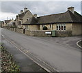
1
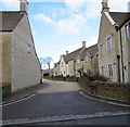
Mill Place, Cirencester
Cul-de-sac and private road on the north side of Barton Lane.
Image: © Jaggery
Taken: 10 Feb 2016
0.01 miles
2
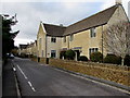
West along Barton Lane, Cirencester
Barton Lane houses are all on the north side, opposite fields and a recreation area.
Image: © Jaggery
Taken: 10 Feb 2016
0.01 miles
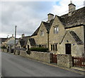
3
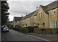
Barton Lane houses, Cirencester
West of the Mill Place junction. http://www.geograph.org.uk/photo/5085401
Image: © Jaggery
Taken: 10 Feb 2016
0.03 miles
4
Access lane to Barton Lane Allotments, Cirencester
From the north side of Barton Lane. The white letters AR are part of a KEEP CLEAR http://www.geograph.org.uk/photo/5085411 painted on Barton Lane.
Image: © Jaggery
Taken: 10 Feb 2016
0.04 miles
5
Barton Lane houses built in 1934, Cirencester
The blue plaque on the wall near the door on the right records that 20 & 22 Barton Lane were built in 1934 for the St John's Hospital Trust. They were designed by the Cotswold architect Norman Jewson.
Image: © Jaggery
Taken: 10 Feb 2016
0.04 miles
6
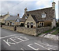
KEEP CLEAR on Barton Lane, Cirencester
Do not obstruct the access lane http://www.geograph.org.uk/photo/5085408 to Barton Lane Allotments.
Image: © Jaggery
Taken: 10 Feb 2016
0.04 miles
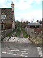
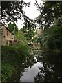
7
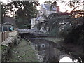
Mill, Barton Lane
View along Mill Pond, on the north-west edge of Cirencester town centre.
www.cirencester.co.uk
Nicholas Henderson 2015 - "There is now a great deal of activity going on with the various authorities concerned regarding the drying up of the Barton Mill Pond (as shown in your photographs). This has followed by letters of complain to the local newspaper as in the summer time the river is drying up when it shouldn't".
Image: © Colin Smith
Taken: 28 Dec 2011
0.06 miles
9
Junction of Barton Lane and St Lawrence Close, Cirencester
Viewed across Barton Lane.
Image: © Jaggery
Taken: 10 Feb 2016
0.07 miles
10
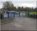
School entrance gates, Barton Lane, Cirencester
Across the entrance to Powell's Church of England Primary School.
Image: © Jaggery
Taken: 10 Feb 2016
0.09 miles