IMAGES TAKEN NEAR TO
Loveday Mews, CIRENCESTER, GL7 2AH
Introduction
This page details the photographs taken nearby to Loveday Mews, GL7 2AH by members of the Geograph project.
The Geograph project started in 2005 with the aim of publishing, organising and preserving representative images for every square kilometre of Great Britain, Ireland and the Isle of Man.

There are currently over 7.5m images from over14,400 individuals and you can help contribute to the project by visiting https://www.geograph.org.uk
Image Map
Images are licensed for reuse under creativecommons.org/licenses/by-sa/2.0
Notes
- Clicking on the map will re-center to the selected point.
- The higher the marker number, the further away the image location is from the centre of the postcode.
Image Listing (1053 Images Found)
Images are licensed for reuse under creativecommons.org/licenses/by-sa/2.0
Image
Details
Distance
1
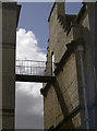
A high way
An open and rather high link between two buildings in Gosditch Street.
Image: © Neil Owen
Taken: 18 Aug 2014
0.02 miles
2
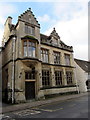
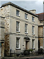
Grade II listed number 15, Gosditch Street, Cirencester
Erected in 1873 as the Capital and Counties Bank.
In February 2016, the name on a bracket above the doorway is
ARBUTHNOTT LADENBURG PARTNERSHIP CHARTERED ARCHITECTS.
Between the lower and upper windows are groups of stone shields.
There is lettering on four of the shields -
CHELTENHAM, STROUD, REDDITCH, STOW-ON-THE-WOLD.
The building was Grade II listed in 1971.
Image: © Jaggery
Taken: 10 Feb 2016
0.02 miles
3
![Cirencester buildings [34]](https://s2.geograph.org.uk/geophotos/06/37/53/6375370_f942d469_120x120.jpg)
Cirencester buildings [34]
This delightful building, number 15 Gosditch Street, was erected in 1873 as the Capital and Counties Bank, now offices housing a firm of architects. Listed, grade II, with details at: https://historicengland.org.uk/listing/the-list/list-entry/1187490
Cirencester, the largest town in the Cotswolds, is a market town some 15 miles south east of Gloucester and some 13 miles north west of Swindon. The town lies on the River Churn, a tributary of the River Thames and is the hub of a network of roads. It is the home of the Royal Agricultural University, founded in 1840. An important Roman settlement known as Corinium, the town, with 240 acres enclosed by walls was second only to London in size.
Image: © Michael Dibb
Taken: 24 Sep 2019
0.02 miles
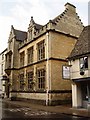
5
Grade II listed Dollar Wand House, Cirencester
3-storey house built c1830-1840. Grade II listed in 1948 (as 11 Gosditch Street).
Image: © Jaggery
Taken: 10 Feb 2016
0.02 miles
6
![Cirencester houses [21]](https://s1.geograph.org.uk/geophotos/06/84/75/6847513_9f2f118f_120x120.jpg)
Cirencester houses [21]
Dollar Ward House, number 11 Gosditch Street, was built circa 1835. Constructed with ashlar to the front and a mixture of coursed and squared and coursed rubble stone to the sides, all under a Welsh slate roof. There is a stone doorcase with Doric columns. Some original internal features remain. Listed, grade II, with details at: https://historicengland.org.uk/listing/the-list/list-entry/1206156
Cirencester, the largest town in the Cotswolds, is a market town some 15 miles south east of Gloucester and some 13 miles north west of Swindon. The town lies on the River Churn, a tributary of the River Thames and is the hub of a network of roads. It is the home of the Royal Agricultural University, founded in 1840. An important Roman settlement known as Corinium, the town, with 240 acres enclosed by walls was second only to London in size.
Image: © Michael Dibb
Taken: 12 May 2021
0.02 miles
7
11 Gosditch Street, Cirencester
A dignified early C19th three-bay house with a Roman Doric doorcase. Grade II listed.
Image: © Stephen Richards
Taken: 16 Aug 2015
0.02 miles
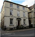
9
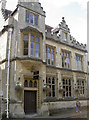
Refined premises
Built in 1873, the Capital and Counties Bank occupied them, followed by the Gloucestershire Bank and then later it was used as municipal offices. Now home to an architects who presumably enjoy an unusual style - quoted as 'eclectic Jacobethan style' by English Heritage. Grade II listed. See Image] for a little detail.
Image: © Neil Owen
Taken: 18 Aug 2014
0.03 miles
10
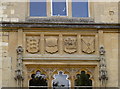
Good in Gosditch
Some of the carvings that add to the unusual style of this old bank. See Image] for a wider view.
Image: © Neil Owen
Taken: 18 Aug 2014
0.03 miles