IMAGES TAKEN NEAR TO
Woodlands Road, CIRENCESTER, GL7 1SP
Introduction
This page details the photographs taken nearby to Woodlands Road, GL7 1SP by members of the Geograph project.
The Geograph project started in 2005 with the aim of publishing, organising and preserving representative images for every square kilometre of Great Britain, Ireland and the Isle of Man.

There are currently over 7.5m images from over14,400 individuals and you can help contribute to the project by visiting https://www.geograph.org.uk
Image Map
Images are licensed for reuse under creativecommons.org/licenses/by-sa/2.0
Notes
- Clicking on the map will re-center to the selected point.
- The higher the marker number, the further away the image location is from the centre of the postcode.
Image Listing (7 Images Found)
Images are licensed for reuse under creativecommons.org/licenses/by-sa/2.0
Image
Details
Distance
1
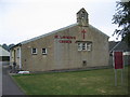
St Lawrence Church Chesterton
Effectively a chapel of ease on the Chesterton estate Cirencester, for the parish church.
Image: © Peter Watkins
Taken: 10 Sep 2005
0.12 miles
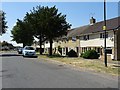
2
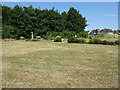
Recreation area, Chestertons, Cirencester
Image: © Philip Halling
Taken: 3 Jul 2018
0.17 miles
4
Bridleway down to Chesterton Farm
Off Chesterton Lane bridleway down to Chesterton Farm
Image: © Shaun Ferguson
Taken: 11 Feb 2012
0.18 miles
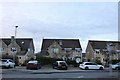
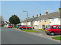
5
Cranshams Lane, Cirencester
Cranshams Lane on a housing estate on the southern edge of the town of Cirencester.
Image: © Philip Halling
Taken: 3 Jul 2018
0.19 miles
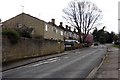
6
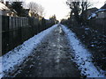
Cranhams Lane, Cirencester
A suburban road to the south of the town centre.
Image: © Jonathan Billinger
Taken: 22 Apr 2010
0.22 miles