IMAGES TAKEN NEAR TO
Querns Road, CIRENCESTER, GL7 1RP
Introduction
This page details the photographs taken nearby to Querns Road, GL7 1RP by members of the Geograph project.
The Geograph project started in 2005 with the aim of publishing, organising and preserving representative images for every square kilometre of Great Britain, Ireland and the Isle of Man.

There are currently over 7.5m images from over14,400 individuals and you can help contribute to the project by visiting https://www.geograph.org.uk
Image Map
Images are licensed for reuse under creativecommons.org/licenses/by-sa/2.0
Notes
- Clicking on the map will re-center to the selected point.
- The higher the marker number, the further away the image location is from the centre of the postcode.
Image Listing (185 Images Found)
Images are licensed for reuse under creativecommons.org/licenses/by-sa/2.0
Image
Details
Distance
1

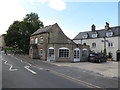
The former Hope Inn Cirencester
Former Hope Inn Cirencester
Historical information links
http://pubshistory.com/Gloucestershire/Cirencester/index.shtml
http://www.gloucestershirepubs.co.uk/FeatureFiller/index.php
Image: © Paul Best
Taken: 28 Mar 2013
0.07 miles
2

Former pub in Cirencester
This building used to be the Hope Inn.
Image: © Malc McDonald
Taken: 11 Jul 2020
0.07 miles
3
Former pub, Cirencester
A former pub in the town of Cirencester, in Gloucestershire. The name of the pub, the Hope Inn, is still partly visible on the wall of the building.
Image: © Malc McDonald
Taken: 11 Jul 2020
0.07 miles
4
![Cirencester buildings [39]](https://s1.geograph.org.uk/geophotos/06/84/56/6845613_5d9dca0f_120x120.jpg)
Cirencester buildings [39]
Now home to a saddlery, this 19th century building was formerly the Hope Inn. Built to serve the workers at the adjacent Thames & Severn Canal basin, the business finally closed in 1975. Constructed of coursed rubble stone under a slate roof with a flat roofed 20th century extension in reconstituted stone.
Cirencester, the largest town in the Cotswolds, is a market town some 15 miles south east of Gloucester and some 13 miles north west of Swindon. The town lies on the River Churn, a tributary of the River Thames and is the hub of a network of roads. It is the home of the Royal Agricultural University, founded in 1840. An important Roman settlement known as Corinium, the town, with 240 acres enclosed by walls was second only to London in size.
Image: © Michael Dibb
Taken: 12 May 2021
0.07 miles
5
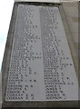
Sheep Street: WW1 names at Apsley Hall (Agg to Johnson)
Image: © Basher Eyre
Taken: 20 Jul 2014
0.08 miles
6
Cirencester Querns Lane Junction With Sheep Street
Image: © Roy Hughes
Taken: 25 Mar 2017
0.08 miles
7

Saddlery on Querns Lane, Cirencester
A former inn.
Image: © JThomas
Taken: 11 Jul 2019
0.08 miles

9
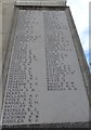
Sheep Street: WW1 names at Apsley Hall (Jones to Wrigley)
Image: © Basher Eyre
Taken: 20 Jul 2014
0.10 miles
10
![Cirencester houses [18]](https://s0.geograph.org.uk/geophotos/06/84/56/6845612_2eed799d_120x120.jpg)
Cirencester houses [18]
Originally six almshouses, now three, numbers 7, 9 and 11 Querns Lane were built in the late 18th or early 19th century. Constructed of coursed squared limestone to the front and coursed squared rubble stone to the sides and rear, with a stone slate roof. There are 20th century rear extensions. Listed, grade II, with details at: https://historicengland.org.uk/listing/the-list/list-entry/1206533
Cirencester, the largest town in the Cotswolds, is a market town some 15 miles south east of Gloucester and some 13 miles north west of Swindon. The town lies on the River Churn, a tributary of the River Thames and is the hub of a network of roads. It is the home of the Royal Agricultural University, founded in 1840. An important Roman settlement known as Corinium, the town, with 240 acres enclosed by walls was second only to London in size.
Image: © Michael Dibb
Taken: 12 May 2021
0.10 miles