IMAGES TAKEN NEAR TO
Mercian Close, CIRENCESTER, GL7 1LT
Introduction
This page details the photographs taken nearby to Mercian Close, GL7 1LT by members of the Geograph project.
The Geograph project started in 2005 with the aim of publishing, organising and preserving representative images for every square kilometre of Great Britain, Ireland and the Isle of Man.

There are currently over 7.5m images from over14,400 individuals and you can help contribute to the project by visiting https://www.geograph.org.uk
Image Map
Images are licensed for reuse under creativecommons.org/licenses/by-sa/2.0
Notes
- Clicking on the map will re-center to the selected point.
- The higher the marker number, the further away the image location is from the centre of the postcode.
Image Listing (84 Images Found)
Images are licensed for reuse under creativecommons.org/licenses/by-sa/2.0
Image
Details
Distance
1
![Cirencester buildings [19]](https://s2.geograph.org.uk/geophotos/06/27/54/6275422_bb0925d8_120x120.jpg)
Cirencester buildings [19]
The Old Foundry, was built circa 1890 by John Delve, Brass and Iron Founder. The business was later sold to a Samuel Jukes and functioned as Jukes Watermoor Foundry until it was again sold to a Fred Hope. (My thanks to Bruce Barker for much of the above information).
Cirencester, the largest town in the Cotswolds, is a market town some 15 miles south east of Gloucester and some 13 miles north west of Swindon. The town lies on the River Churn, a tributary of the River Thames and is the hub of a network of roads. It is the home of the Royal Agricultural University, founded in 1840. An important Roman settlement known as Corinium, the town, with 240 acres enclosed by walls was second only to London in size.
Image: © Michael Dibb
Taken: 31 Jul 2019
0.02 miles
2
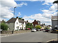
Watermoor Road, Cirencester
Watermoor Road is a residential road in Cirencester, in Gloucestershire. Beyond the first row of houses is a pub.
Image: © Malc McDonald
Taken: 11 Jul 2020
0.03 miles
3
![Cirencester features [6]](https://s1.geograph.org.uk/geophotos/06/27/73/6277393_fe424bf3_120x120.jpg)
Cirencester features [6]
The plaque seen at Image is situated on the side of Watermoor Road, at the junction with City Bank Road. The plaque marks the site of the south eastern gate of the Roman city of Corinium. From the gate the Roman road Ermin Street ran towards Silchester.
Cirencester, the largest town in the Cotswolds, is a market town some 15 miles south east of Gloucester and some 13 miles north west of Swindon. The town lies on the River Churn, a tributary of the River Thames and is the hub of a network of roads. It is the home of the Royal Agricultural University, founded in 1840. An important Roman settlement known as Corinium, the town, with 240 acres enclosed by walls was second only to London in size.
Image: © Michael Dibb
Taken: 31 Jul 2019
0.03 miles
4
![Cirencester features [7]](https://s0.geograph.org.uk/geophotos/06/27/73/6277392_f2380380_120x120.jpg)
Cirencester features [7]
A plaque on the site of the south east gate of the Roman city of Corinium. From the gate the Roman road Ermin Street ran towards Silchester. The plaque is seen in context at Image
Cirencester, the largest town in the Cotswolds, is a market town some 15 miles south east of Gloucester and some 13 miles north west of Swindon. The town lies on the River Churn, a tributary of the River Thames and is the hub of a network of roads. It is the home of the Royal Agricultural University, founded in 1840. An important Roman settlement known as Corinium, the town, with 240 acres enclosed by walls was second only to London in size.
Image: © Michael Dibb
Taken: 31 Jul 2019
0.03 miles
5
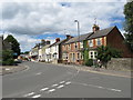
Watermoor Road, Cirencester
Watermoor Road in Cirencester.
Image: © Malc McDonald
Taken: 11 Jul 2020
0.03 miles
6
![Cirencester features [8]](https://s1.geograph.org.uk/geophotos/06/27/54/6275433_24791504_120x120.jpg)
Cirencester features [8]
An information board giving details of the former railway workshops.
Cirencester, the largest town in the Cotswolds, is a market town some 15 miles south east of Gloucester and some 13 miles north west of Swindon. The town lies on the River Churn, a tributary of the River Thames and is the hub of a network of roads. It is the home of the Royal Agricultural University, founded in 1840. An important Roman settlement known as Corinium, the town, with 240 acres enclosed by walls was second only to London in size.
Image: © Michael Dibb
Taken: 31 Jul 2019
0.03 miles
7
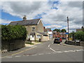
Hare sculpture, Cirencester
A sculpture of a hare on the corner of Watermoor Way and Watermoor Road in Cirencester. Hares feature in the folklore of Cirencester.
Image: © Malc McDonald
Taken: 11 Jul 2020
0.03 miles
8
![Cirencester buildings [20]](https://s3.geograph.org.uk/geophotos/06/27/54/6275423_9afa0af8_120x120.jpg)
Cirencester buildings [20]
Window detail of the Old Foundry seen at Image The Old Foundry, was built circa 1890 by John Delve, Brass and Iron Founder. The business later sold to a Samuel Jukes and functioned as Jukes Watermoor Foundry until it was again sold to a Fred Hope. (My thanks to Bruce Barker for much of the above information).
Cirencester, the largest town in the Cotswolds, is a market town some 15 miles south east of Gloucester and some 13 miles north west of Swindon. The town lies on the River Churn, a tributary of the River Thames and is the hub of a network of roads. It is the home of the Royal Agricultural University, founded in 1840. An important Roman settlement known as Corinium, the town, with 240 acres enclosed by walls was second only to London in size.
Image: © Michael Dibb
Taken: 31 Jul 2019
0.03 miles
9
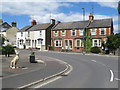
City Bank Road, Cirencester
City Bank Road is a residential road in Cirencester, in Gloucestershire.
Image: © Malc McDonald
Taken: 11 Jul 2020
0.03 miles
10
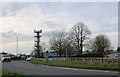
Communication tower by Bristol Road, Cirencester
Image: © David Howard
Taken: 23 Mar 2019
0.04 miles