IMAGES TAKEN NEAR TO
Chester Street, CIRENCESTER, GL7 1HG
Introduction
This page details the photographs taken nearby to Chester Street, GL7 1HG by members of the Geograph project.
The Geograph project started in 2005 with the aim of publishing, organising and preserving representative images for every square kilometre of Great Britain, Ireland and the Isle of Man.

There are currently over 7.5m images from over14,400 individuals and you can help contribute to the project by visiting https://www.geograph.org.uk
Image Map
Images are licensed for reuse under creativecommons.org/licenses/by-sa/2.0
Notes
- Clicking on the map will re-center to the selected point.
- The higher the marker number, the further away the image location is from the centre of the postcode.
Image Listing (118 Images Found)
Images are licensed for reuse under creativecommons.org/licenses/by-sa/2.0
Image
Details
Distance
1
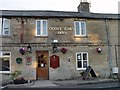
Oddfellows Arms Cirencester
Oddfellows Arms Chester Street Cirencester
Historical information links
http://pubshistory.com/Gloucestershire/Cirencester/index.shtml
http://www.gloucestershirepubs.co.uk/FeatureFiller/index.php
Image: © Paul Best
Taken: 21 Jun 2013
0.02 miles
2
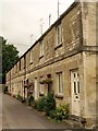
Chester Crescent, Cirencester
An odd name for this pleasant terrace of 11 Cotswold stone houses off Chester Street, as no curve is detectable.
Image: © Derek Harper
Taken: 18 Jul 2008
0.03 miles
3
![Cirencester houses [7]](https://s1.geograph.org.uk/geophotos/06/27/65/6276553_1051dec3_120x120.jpg)
Cirencester houses [7]
Furthest from the camera is a row of three houses - 50, 52 and 54 Chester Street.
Built in the mid 19th century, the row is listed, grade II, with details at: https://historicengland.org.uk/listing/the-list/list-entry/1298697
Near the camera is a pair of houses - 56 and 58 Chester Street. Built in the mid 19th century, the houses are listed, grade II, with details at: https://historicengland.org.uk/listing/the-list/list-entry/1280776
Cirencester, the largest town in the Cotswolds, is a market town some 15 miles south east of Gloucester and some 13 miles north west of Swindon. The town lies on the River Churn, a tributary of the River Thames and is the hub of a network of roads. It is the home of the Royal Agricultural University, founded in 1840. An important Roman settlement known as Corinium, the town, with 240 acres enclosed by walls was second only to London in size.
Image: © Michael Dibb
Taken: 31 Jul 2019
0.05 miles
4
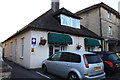
The Old Bungalow Guest House, Victoria Road
Image: © Mike Gentry
Taken: 18 Sep 2010
0.06 miles
5
![Cirencester parks and spaces [4]](https://s3.geograph.org.uk/geophotos/06/27/65/6276543_03c6acf3_120x120.jpg)
Cirencester parks and spaces [4]
St Michael's Park, seen from King Street.
Cirencester, the largest town in the Cotswolds, is a market town some 15 miles south east of Gloucester and some 13 miles north west of Swindon. The town lies on the River Churn, a tributary of the River Thames and is the hub of a network of roads. It is the home of the Royal Agricultural University, founded in 1840. An important Roman settlement known as Corinium, the town, with 240 acres enclosed by walls was second only to London in size.
Image: © Michael Dibb
Taken: 31 Jul 2019
0.08 miles
6
![Cirencester buildings [25]](https://s1.geograph.org.uk/geophotos/06/27/73/6277385_89df28c7_120x120.jpg)
Cirencester buildings [25]
This large school is dated 1880 with later additions at the rear. The school opened in 1881 as Upper School for Boys, superseding Cirencester Grammar School in Park Lane. Later renamed as Cirencester Grammar School, it became a Junior and Infants School and is now Cirencester Primary School. Listed, grade II, with details at: https://historicengland.org.uk/listing/the-list/list-entry/1187531
Cirencester, the largest town in the Cotswolds, is a market town some 15 miles south east of Gloucester and some 13 miles north west of Swindon. The town lies on the River Churn, a tributary of the River Thames and is the hub of a network of roads. It is the home of the Royal Agricultural University, founded in 1840. An important Roman settlement known as Corinium, the town, with 240 acres enclosed by walls was second only to London in size.
Image: © Michael Dibb
Taken: 31 Jul 2019
0.08 miles
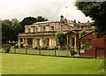
7
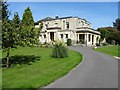
Watermoor House
Watermoor House was built in 1827 and designed by William Jay for Joseph Mullings. The house is Grade II listed, see: https://historicengland.org.uk/listing/the-list/list-entry/1025097 Today the house is a residential care home.
Image: © Philip Halling
Taken: 14 Sep 2019
0.09 miles
8
Watermoor House, Cirencester
Built "in c.1825-27 for Joseph Randolph Mullings, an eminent solicitor who became a Member of Parliament for Cirencester from 1848 to 1859" (http://www.cotswold.gov.uk/media/documents/Heritage/Conservation%20and%20Design/Conservation%20Areas/Cirencester/CA4/DraftCA4Section3_0to3_3_40-46.pdf ), and the first building on what had formerly been common land. Watermoor House is now a residential home for older people. This view is from St Michael's Park.
Image: © Derek Harper
Taken: 18 Jul 2008
0.09 miles
9
![Cirencester buildings [26]](https://s2.geograph.org.uk/geophotos/06/27/73/6277386_6c11de4f_120x120.jpg)
Cirencester buildings [26]
A plaque on Cirencester Primary School Image commemorating the attendance at the school from 1918-1920 of Walter Hammond, later captain of England's cricket team.
Cirencester, the largest town in the Cotswolds, is a market town some 15 miles south east of Gloucester and some 13 miles north west of Swindon. The town lies on the River Churn, a tributary of the River Thames and is the hub of a network of roads. It is the home of the Royal Agricultural University, founded in 1840. An important Roman settlement known as Corinium, the town, with 240 acres enclosed by walls was second only to London in size.
Image: © Michael Dibb
Taken: 31 Jul 2019
0.10 miles
10
![Cirencester houses [8]](https://s1.geograph.org.uk/geophotos/06/27/73/6277389_4c4f406f_120x120.jpg)
Cirencester houses [8]
Number 97 Victoria Road, Frazer House, is a substantial, detached property.
Cirencester, the largest town in the Cotswolds, is a market town some 15 miles south east of Gloucester and some 13 miles north west of Swindon. The town lies on the River Churn, a tributary of the River Thames and is the hub of a network of roads. It is the home of the Royal Agricultural University, founded in 1840. An important Roman settlement known as Corinium, the town, with 240 acres enclosed by walls was second only to London in size.
Image: © Michael Dibb
Taken: 31 Jul 2019
0.11 miles