IMAGES TAKEN NEAR TO
Ormand Close, CIRENCESTER, GL7 1GN
Introduction
This page details the photographs taken nearby to Ormand Close, GL7 1GN by members of the Geograph project.
The Geograph project started in 2005 with the aim of publishing, organising and preserving representative images for every square kilometre of Great Britain, Ireland and the Isle of Man.

There are currently over 7.5m images from over14,400 individuals and you can help contribute to the project by visiting https://www.geograph.org.uk
Image Map
Images are licensed for reuse under creativecommons.org/licenses/by-sa/2.0
Notes
- Clicking on the map will re-center to the selected point.
- The higher the marker number, the further away the image location is from the centre of the postcode.
Image Listing (36 Images Found)
Images are licensed for reuse under creativecommons.org/licenses/by-sa/2.0
Image
Details
Distance
1
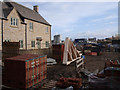
Corinium Via estate under construction
Corinium Via is a new development of 2- to 4-bedroom houses on the outskirts of Cirencester, and is here shown under construction.
Image: © Vieve Forward
Taken: 22 Jan 2012
0.04 miles
2
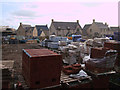
Corinium Via housing estate under construction
Corinium Via is a new development of 2- to 4-bedroom houses on the outskirts of Cirencester, and is here shown under construction.
Image: © Vieve Forward
Taken: 22 Jan 2012
0.05 miles
3
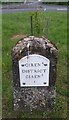
Milestone - Cirencester 1
There is an OS cut mark on the stone.
Image: © Adrian Dust
Taken: 24 Jul 2021
0.05 miles
4
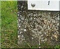
Ordnance Survey Cut Mark
This OS cut mark can be found on the milestone in the centre of the roundabout. It marked a point 127.830m above mean sea level.
Image: © Adrian Dust
Taken: 24 Jul 2021
0.05 miles
5
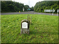
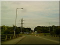
Old Milestone, A417/A429
Repositioned 16m westward, in the centre of the modern island. In its original position (see Image would have represented 420.1 ft Above Sea Level (128m in 1901) and the 1960s 127.8m.
Milestone Society National ID: GL_CIBF01
Image: © Mr Red
Taken: 9 Oct 2021
0.06 miles
6
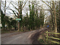
Entrance to Hare Bushes Wood
Track at entrance to Hare Bushes Wood. Part of Abbey Home Farm, this is a permissive path for walkers, and vehicular access is not allowed.
Image: © Vieve Forward
Taken: 22 Jan 2012
0.07 miles
7

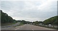
A417 - A429 (Fosse Way) overbridge
Ermin Way's successor meets the course of Fosse Way and Akeman Street. Almost 2000 years separates the generations of road engineering excellence.
Image: © J Whatley
Taken: 22 Sep 2010
0.07 miles
8
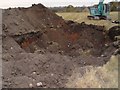
Clearing The Edwardian Dump In Cirencester
Looking from the field next to Burford Road towards Arnolds Way Cirencester
Image: © Paul Best
Taken: 28 Oct 2003
0.08 miles