IMAGES TAKEN NEAR TO
Golden Farm Road, CIRENCESTER, GL7 1BZ
Introduction
This page details the photographs taken nearby to Golden Farm Road, GL7 1BZ by members of the Geograph project.
The Geograph project started in 2005 with the aim of publishing, organising and preserving representative images for every square kilometre of Great Britain, Ireland and the Isle of Man.

There are currently over 7.5m images from over14,400 individuals and you can help contribute to the project by visiting https://www.geograph.org.uk
Image Map
Images are licensed for reuse under creativecommons.org/licenses/by-sa/2.0
Notes
- Clicking on the map will re-center to the selected point.
- The higher the marker number, the further away the image location is from the centre of the postcode.
Image Listing (10 Images Found)
Images are licensed for reuse under creativecommons.org/licenses/by-sa/2.0
Image
Details
Distance
2
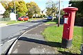
George VI pillar box
George VI pillar box on the corner of Abbots Road and Akeman Road on the Beeches estate.
Image: © Philip Halling
Taken: 10 Oct 2022
0.10 miles
3
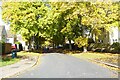
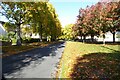
Trees on Saxon Road
Trees in autumn colours on Saxon Road on the Beeches estate.
Image: © Philip Halling
Taken: 10 Oct 2022
0.10 miles
4
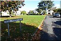
Blue Quarry Road
Blue Quarry Road on the Beeches estate.
Image: © Philip Halling
Taken: 10 Oct 2022
0.12 miles
5
Saxon Road
Trees in autumn colours on Saxon Road on the Beeches estate.
Image: © Philip Halling
Taken: 10 Oct 2022
0.15 miles
6
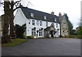
The Golden Farm (1), Upper Churnside, Cirencester, Glos
A large local pub serving the Beeches Estate area. The building appears much older than the neighbouring houses and presumably was once a farmhouse.
Image
Image: © P L Chadwick
Taken: 18 Dec 2014
0.21 miles
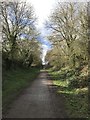
7
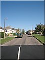
Golden Farm Road
Golden Farm Road on the Beeches Estate. The main features of this square are a number of 1950's housing estates, a bypass and a section of old Roman city wall
Image: © Dave Bushell
Taken: 2 Sep 2005
0.22 miles
8
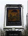
The Golden Farm (2) - sign, Upper Churnside, Cirencester, Glos
The sign is on a post outside the pub. The building was probably originally a farmhouse.
Image
Image: © P L Chadwick
Taken: 18 Dec 2014
0.22 miles
9
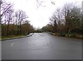
Roundabout and bridge, Beeches Road, Cirencester, Glos
The roundabout is in front of the Golden Farm public house. On the other side of the roundabout is the bridge which takes Beeches Road across the A429 dual carriageway road.
Image: © P L Chadwick
Taken: 18 Dec 2014
0.23 miles
10
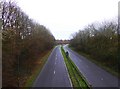
The A429 road heading towards Swindon, at Cirencester, Glos
Looking south-southeast from the bridge at the end of Beeches Road.
Image
Image: © P L Chadwick
Taken: 18 Dec 2014
0.24 miles