IMAGES TAKEN NEAR TO
Beeches Road, CIRENCESTER, GL7 1BN
Introduction
This page details the photographs taken nearby to Beeches Road, GL7 1BN by members of the Geograph project.
The Geograph project started in 2005 with the aim of publishing, organising and preserving representative images for every square kilometre of Great Britain, Ireland and the Isle of Man.

There are currently over 7.5m images from over14,400 individuals and you can help contribute to the project by visiting https://www.geograph.org.uk
Image Map
Images are licensed for reuse under creativecommons.org/licenses/by-sa/2.0
Notes
- Clicking on the map will re-center to the selected point.
- The higher the marker number, the further away the image location is from the centre of the postcode.
Image Listing (77 Images Found)
Images are licensed for reuse under creativecommons.org/licenses/by-sa/2.0
Image
Details
Distance
1
![Cirencester parks and spaces [5]](https://s0.geograph.org.uk/geophotos/06/37/41/6374128_88dfe744_120x120.jpg)
Cirencester parks and spaces [5]
The Beeches car park has 145 spaces and is convenient for The Barn theatre and Ingleside House venue.
Cirencester, the largest town in the Cotswolds, is a market town some 15 miles south east of Gloucester and some 13 miles north west of Swindon. The town lies on the River Churn, a tributary of the River Thames and is the hub of a network of roads. It is the home of the Royal Agricultural University, founded in 1840. An important Roman settlement known as Corinium, the town, with 240 acres enclosed by walls was second only to London in size.
Image: © Michael Dibb
Taken: 24 Sep 2019
0.05 miles
3
![Cirencester buildings [29]](https://s3.geograph.org.uk/geophotos/06/37/41/6374127_faf9db59_120x120.jpg)
Cirencester buildings [29]
This fine coped garden wall is attached to Ingleside House and is part of the grade II listing with details at: https://historicengland.org.uk/listing/the-list/list-entry/1187421
Cirencester, the largest town in the Cotswolds, is a market town some 15 miles south east of Gloucester and some 13 miles north west of Swindon. The town lies on the River Churn, a tributary of the River Thames and is the hub of a network of roads. It is the home of the Royal Agricultural University, founded in 1840. An important Roman settlement known as Corinium, the town, with 240 acres enclosed by walls was second only to London in size.
Image: © Michael Dibb
Taken: 24 Sep 2019
0.06 miles
4

Ingleside House, 5 Beeches Road, Cirencester, Glos
Originally dating from the late 18th century, with later alterations and additions, this large building was originally known as The Beeches, and occupied by the Chester-Masters family, one of Cirencester's leading landowners. It has subsequently been used as offices, for school purposes and was for many years occupied and run by Cirencester Community Association. In recent years it has become an events and conference centre. Under the same management in adjoining premises are The Barn, a small theatre, and The Vaults, a public house. Ingleside House is Grade II listed.
Image: © P L Chadwick
Taken: 22 Dec 2013
0.07 miles
5
![Cirencester buildings [28]](https://s1.geograph.org.uk/geophotos/06/37/41/6374125_223d4d0d_120x120.jpg)
Cirencester buildings [28]
Ingleside House, was originally named The Beeches. Later it was named Ingleside School and later again, when used as a community centre, The Phoenix Centre. Now a conference and wedding venue with the Barn Theatre and a restaurant as part of the complex. There is a detailed history of the house at: https://www.inglesidehouse.co.uk/history The building is late 18th century with alterations and additions in the early and mid 19th century and in the early 20th century and contains many fine original internal features. Listed, grade II, with details at: https://historicengland.org.uk/listing/the-list/list-entry/1187421
Cirencester, the largest town in the Cotswolds, is a market town some 15 miles south east of Gloucester and some 13 miles north west of Swindon. The town lies on the River Churn, a tributary of the River Thames and is the hub of a network of roads. It is the home of the Royal Agricultural University, founded in 1840. An important Roman settlement known as Corinium, the town, with 240 acres enclosed by walls was second only to London in size.
Image: © Michael Dibb
Taken: 24 Sep 2019
0.08 miles
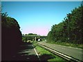
6
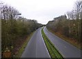
The A429 road heading towards Northleach, at Cirencester, Glos
Looking north-northwest from the bridge at the end of Beeches Road.
Image
Image: © P L Chadwick
Taken: 18 Dec 2014
0.08 miles
7
![Cirencester houses [10]](https://s0.geograph.org.uk/geophotos/06/37/47/6374768_531c8d23_120x120.jpg)
Cirencester houses [10]
Terraced housing in Purley Road.
Cirencester, the largest town in the Cotswolds, is a market town some 15 miles south east of Gloucester and some 13 miles north west of Swindon. The town lies on the River Churn, a tributary of the River Thames and is the hub of a network of roads. It is the home of the Royal Agricultural University, founded in 1840. An important Roman settlement known as Corinium, the town, with 240 acres enclosed by walls was second only to London in size.
Image: © Michael Dibb
Taken: 24 Sep 2019
0.08 miles
8
![Cirencester buildings [27]](https://s0.geograph.org.uk/geophotos/06/37/41/6374124_ea38f84e_120x120.jpg)
Cirencester buildings [27]
The recently refurbished Barn theatre is part of Ingleside House. The theatre started life in a 1940s Nissen hut but is now capable of seating 200 patrons. There is a detailed history of the house at: https://www.inglesidehouse.co.uk/history The house is listed, grade II, with details at: https://historicengland.org.uk/listing/the-list/list-entry/1187421
Cirencester, the largest town in the Cotswolds, is a market town some 15 miles south east of Gloucester and some 13 miles north west of Swindon. The town lies on the River Churn, a tributary of the River Thames and is the hub of a network of roads. It is the home of the Royal Agricultural University, founded in 1840. An important Roman settlement known as Corinium, the town, with 240 acres enclosed by walls was second only to London in size.
Image: © Michael Dibb
Taken: 24 Sep 2019
0.09 miles
9
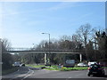
Cirencester Burford Road A429 Swindon Road From Island
Image: © Roy Hughes
Taken: 25 Mar 2017
0.09 miles
10
![Cirencester houses [9]](https://s2.geograph.org.uk/geophotos/06/37/41/6374122_a0b0d0d1_120x120.jpg)
Cirencester houses [9]
Numbers 6, 8 and 10 London Road are late 18th or early 19th century. Number 6 was a double fronted house and was later divided into two dwellings. Listed, grade II, with details at: https://historicengland.org.uk/listing/the-list/list-entry/1206207
Cirencester, the largest town in the Cotswolds, is a market town some 15 miles south east of Gloucester and some 13 miles north west of Swindon. The town lies on the River Churn, a tributary of the River Thames and is the hub of a network of roads. It is the home of the Royal Agricultural University, founded in 1840. An important Roman settlement known as Corinium, the town, with 240 acres enclosed by walls was second only to London in size.
Image: © Michael Dibb
Taken: 24 Sep 2019
0.11 miles