IMAGES TAKEN NEAR TO
Farm Close, STROUD, GL6 9NA
Introduction
This page details the photographs taken nearby to Farm Close, GL6 9NA by members of the Geograph project.
The Geograph project started in 2005 with the aim of publishing, organising and preserving representative images for every square kilometre of Great Britain, Ireland and the Isle of Man.

There are currently over 7.5m images from over14,400 individuals and you can help contribute to the project by visiting https://www.geograph.org.uk
Image Map
Images are licensed for reuse under creativecommons.org/licenses/by-sa/2.0
Notes
- Clicking on the map will re-center to the selected point.
- The higher the marker number, the further away the image location is from the centre of the postcode.
Image Listing (55 Images Found)
Images are licensed for reuse under creativecommons.org/licenses/by-sa/2.0
Image
Details
Distance
1
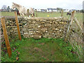
Stone Stile, Minchinhampton
A step stile of fairly recent vintage, as can be seen on this view looking North, the view looking South is Image
Image: © Mr Red
Taken: 31 Dec 2021
0.10 miles
2
Stone Stile, Minchinhampton
A step stile of fairly recent vintage, as can be seen on the other view looking North Image
Image: © Mr Red
Taken: 31 Dec 2021
0.10 miles
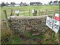
3
Stone Stile, Minchinhampton
Between the horse grazing and arable fields on Gloucestershire footpath MMH145, looking SW. The view looking NE is Image
Image: © Mr Red
Taken: 31 Dec 2021
0.10 miles
4
Stone Stile, Minchinhampton
Between the Horse grazing and arable fields on Gloucestershire footpath MMH145, looking NE. The view looking SW is Image
Image: © Mr Red
Taken: 31 Dec 2021
0.10 miles
5

Private road to Glebe Farm, Minchinhampton
From Tobacconist Road.
Image: © Jaggery
Taken: 6 Mar 2016
0.15 miles
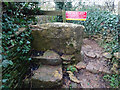
6
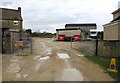
Entrance to Tobacconist Farm Minchinhampton
From Tobacconist Road. This way to Tobacconist Farm Camping and Caravan site.
Image: © Jaggery
Taken: 6 Mar 2016
0.17 miles
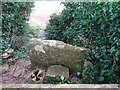
7

Restricted Area notice at the entrance to Tobacconist Farm, Minchinhampton
Located here. http://www.geograph.org.uk/photo/5135550 The gate leads to a public footpath through private land.
There are free roaming livestock ahead, so dogs must be on leads at all times.
Image: © Jaggery
Taken: 6 Mar 2016
0.18 miles
8

Fork in the road, Minchinhampton
From Tobacconist Road. Left fork is a private road to Glebe Farm.
Right fork for Tobacconist Farm and Tobacconist Farm Camping and Caravan site.
Image: © Jaggery
Taken: 6 Mar 2016
0.18 miles
9

Highmead, Minchinhampton
Tobacconist Road house near Tobacconist Farm.
Image: © Jaggery
Taken: 6 Mar 2016
0.18 miles
10

Tobacconist Road, Minchinhampton
Viewed across Tetbury Street looking along Tobacconist Road towards Tobacconist Farm.
Image: © Jaggery
Taken: 6 Mar 2016
0.20 miles