IMAGES TAKEN NEAR TO
Tetbury Street, STROUD, GL6 9JH
Introduction
This page details the photographs taken nearby to Tetbury Street, GL6 9JH by members of the Geograph project.
The Geograph project started in 2005 with the aim of publishing, organising and preserving representative images for every square kilometre of Great Britain, Ireland and the Isle of Man.

There are currently over 7.5m images from over14,400 individuals and you can help contribute to the project by visiting https://www.geograph.org.uk
Image Map
Images are licensed for reuse under creativecommons.org/licenses/by-sa/2.0
Notes
- Clicking on the map will re-center to the selected point.
- The higher the marker number, the further away the image location is from the centre of the postcode.
Image Listing (227 Images Found)
Images are licensed for reuse under creativecommons.org/licenses/by-sa/2.0
Image
Details
Distance
1
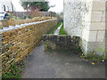
Stone Stile, Minchinhampton
Off Tetbury St on the Gloucestershire footpath MMH106, looking South. The footpath leads to Chapel Street. The view looking North is Image
Image: © Mr Red
Taken: 31 Dec 2021
0.01 miles
2
Stone Stile, Minchinhampton
Off Tetbury St on the Gloucestershire footpath MMH106, looking North. The footpath leads to Chapel Street. The view looking South is Image
Image: © Mr Red
Taken: 31 Dec 2021
0.01 miles
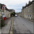
3

Tetbury Street towards the centre of Minchinhampton
Looking WNW from opposite the Tobacconist Road junction. http://www.geograph.org.uk/photo/4856776
Image: © Jaggery
Taken: 6 Mar 2016
0.01 miles
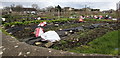
4

Allotments perimeter wall, Friday Street, Minchinhampton
At the western edge of a rectangular area of allotments about 150 metres long and 60 metres wide.
Image: © Jaggery
Taken: 6 Mar 2016
0.01 miles
5
Warning sign - minor road junction ahead, Tetbury Street, Minchinhampton
Below the triangular warning sign, a small white-on-green sign points left to this http://www.geograph.org.uk/photo/5152033 public footpath.
Image: © Jaggery
Taken: 6 Mar 2016
0.01 miles
6

Tetbury Street houses, Minchinhampton
From the corner of Friday Street http://www.geograph.org.uk/photo/5152002 towards the centre of Minchinhampton.
Image: © Jaggery
Taken: 6 Mar 2016
0.01 miles
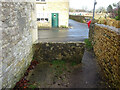
7
Southwest corner of Minchinhampton Allotments
On the corner of Friday Street and Tetbury Street. Tobacconist Road is beyond the far end of the allotments.
Image: © Jaggery
Taken: 6 Mar 2016
0.02 miles
8

Julie's Hairstylist in Minchinhampton
Shop at 31 Tetbury Street.
Image: © Jaggery
Taken: 6 Mar 2016
0.02 miles
9

Former Minchinhampton Institute
MINCHINHAMPTON INSTITUTE ERECTED 1907 is inscribed in stone above the first floor pair of windows on the right. In March 2016, the name sign on the lower right shows MBC (Minchinhampton Baptist Church) Church Centre and Church Office. The church building http://www.geograph.org.uk/photo/5148902 is out of shot on the right.
Image: © Jaggery
Taken: 6 Mar 2016
0.03 miles
10

Grade II listed 30 and 32 Tetbury Street, Minchinhampton
Pair of 18th century houses viewed from the corner of Friday Street.
Number 32 on the left has a pedimented porch. The pair of houses were Grade II listed in 1988.
Image: © Jaggery
Taken: 6 Mar 2016
0.03 miles