IMAGES TAKEN NEAR TO
Cambridge Way, STROUD, GL6 9DE
Introduction
This page details the photographs taken nearby to Cambridge Way, GL6 9DE by members of the Geograph project.
The Geograph project started in 2005 with the aim of publishing, organising and preserving representative images for every square kilometre of Great Britain, Ireland and the Isle of Man.

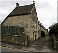
There are currently over 7.5m images from over14,400 individuals and you can help contribute to the project by visiting https://www.geograph.org.uk
Image Map
Images are licensed for reuse under creativecommons.org/licenses/by-sa/2.0
Notes
- Clicking on the map will re-center to the selected point.
- The higher the marker number, the further away the image location is from the centre of the postcode.
Image Listing (158 Images Found)
Images are licensed for reuse under creativecommons.org/licenses/by-sa/2.0
Image
Details
Distance
1
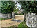
Gateway and cattle grid
Most properties in the village have cattle grids to keep out the local cattle which graze freely on the Common.
Image: © Graham Hogg
Taken: 19 Oct 2021
0.07 miles
2
Southern end of Dr Brown's Road, Minchinhampton
Looking north from Windmill Road.
Image: © Jaggery
Taken: 6 Mar 2016
0.09 miles
3
Kissing Gate, Minchinhampton Common
In "the Park" section of the common. A private kissing gate to the left of the entrance to "Widgets" alongside Gloucestershire footpath MMH149. The fuller view is Image
Image: © Mr Red
Taken: 4 Jan 2023
0.09 miles
4
Kissing Gate, Minchinhampton Common
In "the Park" section of the common. A private kissing gate entrance to "Widgets" alongside Gloucestershire footpath MMH149. The view showing the entrance is Image
Image: © Mr Red
Taken: 4 Jan 2023
0.09 miles
5

Terrace of Cotswold stone houses, Minchinhampton
The terrace of about a dozen houses has a gable-ended property at each end
Image: © David Smith
Taken: 8 Jun 2018
0.12 miles
6
Grade II listed Park Terrace Minchinhampton
Dating from 1833, the row of 14 houses extends for 80 metres from Dr Brown's Road. Grade II listed in 1975.
Image: © Jaggery
Taken: 6 Mar 2016
0.12 miles
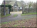
7
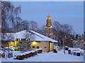
Minchinhampton School
Minchinhampton School with Holy Trinity Church in the background. Photo taken from School Car Park.
Image: © P Dyer
Taken: 6 Feb 2009
0.12 miles
8
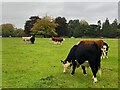
Cattle grazing on The Park
The Park is linked to Minchinhampton Common where cattle graze freely.
Image: © Graham Hogg
Taken: 19 Oct 2021
0.13 miles
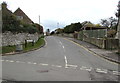
9
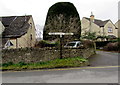
Windmill Road signpost, Minchinhampton
Opposite the southern end of Dr Brown's Road. http://www.geograph.org.uk/photo/5034826
Turn left for Avening and Tetbury. Turn right for Burleigh and Brimscombe.
Image: © Jaggery
Taken: 6 Mar 2016
0.13 miles
10

Windmill Road, Minchinhampton
Looking west along Windmill Road from the western end of West End.
Image: © Jaggery
Taken: 6 Mar 2016
0.13 miles