IMAGES TAKEN NEAR TO
Rack Hill, STROUD, GL6 8LA
Introduction
This page details the photographs taken nearby to Rack Hill, GL6 8LA by members of the Geograph project.
The Geograph project started in 2005 with the aim of publishing, organising and preserving representative images for every square kilometre of Great Britain, Ireland and the Isle of Man.

There are currently over 7.5m images from over14,400 individuals and you can help contribute to the project by visiting https://www.geograph.org.uk
Image Map
Images are licensed for reuse under creativecommons.org/licenses/by-sa/2.0
Notes
- Clicking on the map will re-center to the selected point.
- The higher the marker number, the further away the image location is from the centre of the postcode.
Image Listing (47 Images Found)
Images are licensed for reuse under creativecommons.org/licenses/by-sa/2.0
Image
Details
Distance
1
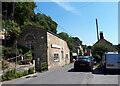
Village shop, High Street
Community-run village shop in former chapel.
Image: © Vieve Forward
Taken: 13 Aug 2022
0.07 miles
2
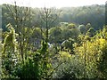
South across the Frome valley, Chalford
The valley carries not only the river but a disused canal and the Gloucester to Swindon railway. All are hidden in the view by the trees that feature along both sides of the valley.
Image: © Brian Robert Marshall
Taken: 24 Oct 2008
0.08 miles
3
Walking east beside the (disused) Thames and Severn Canal
The bridge ahead gives private access to properties to the south.
Image: © David Purchase
Taken: 20 Apr 2017
0.10 miles
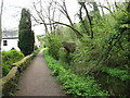
4

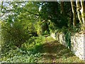
Footpath, Rack Hill, Chalford
This footpath runs along the contour of the south-facing valley overlooking the River Frome. Note the property in the lower right corner. Reminds me of the tale of Mrs Tiggywinkle. If you don't know what I'm on about you're probably a lot younger than I am.
Image: © Brian Robert Marshall
Taken: 24 Oct 2008
0.10 miles
5
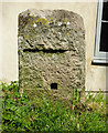
Milestone at the Red Lion
on the towpath of the Thames & Severn, at Chalford
Walbridge 4½ / Inglesham 24¼
Milestone Society National ID: TSC-04½
Image: © Mr Red
Taken: 29 Apr 2019
0.10 miles
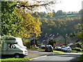
6
West along a footpath, Rack Hill, Chalford
The same path as in this image but in the opposite direction http://www.geograph.org.uk/photo/1020156 The path runs parallel to High Street, to the left, out of shot.
Image: © Brian Robert Marshall
Taken: 24 Oct 2008
0.11 miles
7
Coppice Hill, Chalford
The hill heads south down the valley side to the main road at the bottom.
Image: © Brian Robert Marshall
Taken: 24 Oct 2008
0.12 miles
8
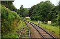
Chalford railway station (site), Gloucestershire
Opened in 1897 by the Great Western Railway on the line from Swindon to Gloucester, this station closed in 1964.
View east towards Tetbury Road and Swindon. The station is long gone but is commemorated by the road on the left being named "Old Station Close".
Image: © Nigel Thompson
Taken: 9 Oct 2021
0.13 miles
9
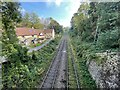
The Swindon - Gloucester line near Chalford
Image: © Steve Daniels
Taken: 2 Sep 2009
0.14 miles
10
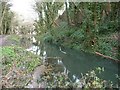
The Thames & Severn Canal, east of the A419, Chalford
This will be phase 3 of the Cotswold Canals Trust's restoration programme.
Image: © Christine Johnstone
Taken: 28 Mar 2016
0.14 miles