
IMAGES TAKEN NEAR TO
Frampton Mansell, STROUD, GL6 8JB
Introduction
This page details the photographs taken nearby to GL6 8JB by members of the Geograph project.
The Geograph project started in 2005 with the aim of publishing, organising and preserving representative images for every square kilometre of Great Britain, Ireland and the Isle of Man.

There are currently over 7.5m images from over14,400 individuals and you can help contribute to the project by visiting https://www.geograph.org.uk
Image Map
Images are licensed for reuse under creativecommons.org/licenses/by-sa/2.0
Notes
- Clicking on the map will re-center to the selected point.
- The higher the marker number, the further away the image location is from the centre of the postcode.
Image Listing (50 Images Found)
Images are licensed for reuse under creativecommons.org/licenses/by-sa/2.0
Image
Details
Distance
1

Stone Stile, Frampton Mansell
On Gloucestershire footpath BSA10, running alongside Pike Cottage and Frampton Farm. This is looking East to the road, the view from the road is Image
Image: © Mr Red
Taken: 10 Apr 2022
0.01 miles
2

Stone Stile, Frampton Mansell
On Gloucestershire footpath BSA10, running alongside Pike Cottage and Frampton Farm. This is looking West from the road, the view from the path is Image
Image: © Mr Red
Taken: 10 Apr 2022
0.01 miles
3

Frampton Mansell from Far Oakridge
The early Victorian St Luke's Church http://www.geograph.org.uk/photo/581656 done in the Italian style is visible at the lower right.
Image: © Brian Robert Marshall
Taken: 19 Jun 2012
0.11 miles
4

Bench Mark, Woodcote
The Ordnance Survey bench mark is to be found on the northwest face of the building. For a view of the house Image and for further information on the bench mark http://www.bench-marks.org.uk/bm40239
Image: © Maigheach-gheal
Taken: 12 Aug 2011
0.12 miles
5

Woodcote, Frampton Mansell
On the nearest angle of the house is an Ordnance Survey bench mark.
Image: © Maigheach-gheal
Taken: 12 Aug 2011
0.12 miles
6
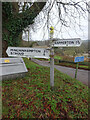
Old Fingerpost, Frampton Mansell
On Main Street in the centre of the village. The post is of the old design with castellated sleeves. The fingers are modern.
Inscription: Sapperton 1¾ //Minchinhampton 3½ / Stroud 6
Milestone Society National ID: GL_SO9202
Image: © Mr Red
Taken: 10 Jan 2022
0.13 miles
7

Bench Mark, Old School House
The Ordnance Survey bench mark is to be found on the southeast face of the building. For a wider view of the building Image and for further information on the cut mark and others in the area http://www.bench-marks.org.uk/bm40240
Image: © Maigheach-gheal
Taken: 12 Aug 2011
0.13 miles
8

Old School House, Frampton Mansell
On the southeast face of the building is an Ordnance Survey bench mark.
Image: © Maigheach-gheal
Taken: 12 Aug 2011
0.13 miles
9

Footpath, Frampton Mansell
The footpath passes to the side of the churchyard and it links two minor village lanes.
Image: © Maigheach-gheal
Taken: 12 Aug 2011
0.13 miles
10

Frampton Mansell from Far Oakridge
This is another long view of the Cotswolds village a kilometre north of the A419 Cirencester to Stroud road. The village sits on the north-facing side of the Frome valley.
Image: © Brian Robert Marshall
Taken: 19 Jun 2012
0.14 miles