IMAGES TAKEN NEAR TO
Cowcombe Lane, STROUD, GL6 8HR
Introduction
This page details the photographs taken nearby to Cowcombe Lane, GL6 8HR by members of the Geograph project.
The Geograph project started in 2005 with the aim of publishing, organising and preserving representative images for every square kilometre of Great Britain, Ireland and the Isle of Man.

There are currently over 7.5m images from over14,400 individuals and you can help contribute to the project by visiting https://www.geograph.org.uk
Image Map
Images are licensed for reuse under creativecommons.org/licenses/by-sa/2.0
Notes
- Clicking on the map will re-center to the selected point.
- The higher the marker number, the further away the image location is from the centre of the postcode.
Image Listing (4 Images Found)
Images are licensed for reuse under creativecommons.org/licenses/by-sa/2.0
Image
Details
Distance
1
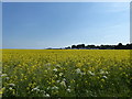
Gliders on Aston Down airfield
The field between the boundary fence and runways is planted with oilseed rape.
Image: © Vieve Forward
Taken: 19 May 2018
0.11 miles
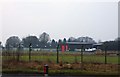
4
Cotswold Gliding Club
The former Aston Down airfield was bought by the gliding club in 1981. The club moved here in 1967.
Image: © John M
Taken: 19 Feb 2013
0.23 miles